Tuesday, April 9, 2013

Religious Use of Elephants in Ancient Sri Lanka (Research Paper)

Citation: Wisumperuma, D. 2012, Religious Use of Elephants in Ancient Sri Lanka, Gajah, 37, pp. 16-21.

Abstract

The religious use of elephants in Sri Lanka has its origins in the early period of Buddhism in Sri Lanka. The oldest record of the use of elephants in Buddhist religious processions and festivals in Sri Lanka dates back to 3rd century BCE, when Buddhism was introduced to the Island. The oldest record of the use of elephants to draw a chariot with the Tooth Relic in a procession is from early 14th century CE, centuries prior to the commencement of the Kandy Esala Perahera in the 18th century. Elephants used for religious purposes during the early periods were mostly state elephants belonging to the king and in some cases the royal or Mangala elephant. However a number of elephants were used in religious festivals later and that perhaps required more elephants from other sources. The first recorded donation of an elephant to a temple took place in the early 1st century CE. This could be a continuation of a former tradition. Offering of elephants to temples are frequently mentioned in historical sources since 14th century CE.

Full paper (PDF): http://www.asesg.org/PDFfiles/2013/Gajah%2037/37-16-Wisumperuma.pdf

Contents page: http://www.asesg.org/gajah37.htm


Wednesday, April 3, 2013

Time forgotten temple in Nuwaragala

Dhanesh Wisumperuma


The Nation, 2013-03-03, Fine, p.6-7


View from the top of the rock

‘Nuwaragala’ was a small junction with few boutiques which we came across while on our journey from Ihala Yakkure to Siripura, a small township. The name sounded familiar as there are two other Nuwaragalas known to travellers and explorers. The most famous Nuwaragala is close to Maha Oya, a rock which contains numerous ruins, and could be approached via the Akulobe village. The second Nuwaragala (Nuwaragalakanda) is situated near the district border of Polonnaruwa and Kandy and close to Wewala, a small village near Sigiriya. It is also a ruined site of archaeological interest.

I was thus a little confused with this third Nuwaragala near Yakkure. It appeared to be of recent origin as such a place was not marked on one inch or metric maps. There are many such place names that have been coined after the Mahaweli settlements came up in the area. My companions were of the same opinion.

While driving along the road that ran along the bank of an irrigation canal, we suddenly came across a signboard of a temple called ‘Sugala Devi Rajamaha Viharaya’ with the prefix ‘historic’ (Eithihasika). Interest in history and archaeology prompted us to explore this temple. The temple was situated on a small rock which rose from the almost flat terrain. When we crossed the canal, there was a path which led towards the temple buildings at the base of the rock and the shrines on the summit.


Remains of a bygone era

There were steps made of concrete to climb up the hill constructed courtesy donations made by recent devotees; their names were inscribed on the concrete but, worn out or covered with moss. About halfway up the rock, there is an image house of relatively recent construction, which is being renovated. Close to it is a seated Buddha statue under a canopy built recently but well maintained.

There was also a relic from the ancient past; it was lying between the statue and the image house, on the ground and neglected. It was a large stone slab, possibly used as an asana (a flower altar), weather-worn. There were signs or rather remnants of an inscription, written within parallel lines. There were about twenty or more lines but the letters were indecipherable to the naked eye. There was one more important artefact on the site. A small piece of an octagonal pillar was found close to the Buddha statue, which resembled a part of the Yupa stone of the old stupa. 


We climbed towards the top of the hill, where a small stupa was seen. The path was covered with weeds and it gave the impression that the stupa, a recent and rough construction, is not visited regularly by devotees. Near the stupa was a siri-patul-gala (sacred foot-print on stone) which is used to represent the Buddha before the Buddha statue came into vogue, i.e. in the early Anuradhapura period.

To the left of this stupa was a small mound. A closer look revealed what it is an old ruined stupa. There were pieces of bricks here and there on the summit as well as on the slopes. We were shocked to see the large rectangular hole dug into the area where the relic chamber of the stupa may have been located. It was about more than 2 meters deep. The excavation seemed to have been done several years previously, and it was partly covered with weeds and filled with rubble. However, a small part of the wall of this stupa was intact on one side.The view from the summit of the rock was fascinating. There were forest patches, open areas and about three different mountain ranges to the south and south-west of us.

Finding the history of the temple

We had the opportunity to have a discussion with the chief incumbent of the temple, Ven. Mapakada Sumangala Thera and benefit from his cordial hospitality. According to him, the modern temple has its origins in the late 1980s, parallel to the development of Mahaweli settlements. People had called the ruined temple Kotavehera (Short Stupa) or Gale Pansala (Temple of the Rock) at that time. The present name of the temple, Sugaladevi Raja Maha Vihara indicates a connection to the Polonnaruwa Period, but we didn’t see any strong evidence to connect the temple to that period.

However, the temple definitely has a history going back to the early Anuradhapura Period. The siri-patul-gala, asana gala and the possible remnants of the yupa gala points to this, but would have to be backed by further evidence. More systematic exploration is required in identifying what else remains in this lesser-known archaeological site.

Pics Bushana Kalhara


What’s lost in Yakkure

What’s lost in Yakkure: Transformation from an old village to the new settlement


Dhanesh Wisumperuma


The Nation, 2013-02-24, Fine, p. 6-7

http://www.nation.lk/edition/fine/item/16040-what%E2%80%99s-lost-in-yakkure.html (this link is not working now)


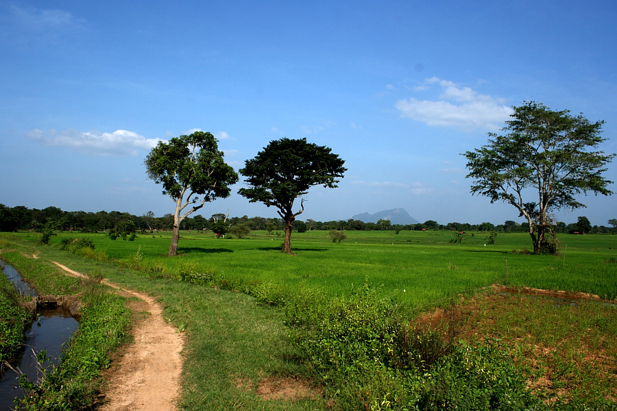
Lush paddy fields of Yakkure with Dimbulagala in the backdrop

The mountain seen over the paddy fields to the east of us was the well known Dimbulagala. Rising above the flat terrain and glittering under the afternoon sun, it resembled the cultural and religious heritage of the area we were walking in. The lush green of the paddy, after the recent rains, was pleasant to the eyes. Beyond the line of vegetation should be the Handapan Villu, an important wetland. One of the schoolteachers who accompanied us pointed at a few tamarind trees on our path and scattered among paddy fields. Tamarind trees are signs of human habitation and this reminded me of a statement in Dr R L Spittel’s Wild Ceylon, “… itself was a negligently palisaded hamlet nestling in a grove of tamarinds, in full view of a beautiful Wewa” These could be the same trees.

We were walking towards Yakkure, or the old abandoned Yakkure village, known to some interesting Sri Lankans. Yakkure is a small village situated in Dimbulagala DS Division in the Polonnaruwa District. On the map, this village is situated within a distance of a little over ten kilometers from Polonnaruwa on the other side of Mahaweli. However one has to take an encircling route travelling along the Manampitiya-Dimbulagala-Siripura Road that is about four times longer than that, to reach the village. It is situated in close proximity to the Mahaweli River, actually within and close to the flood plain.

Yakkure is mentioned occasionally in history, both ancient and modern. The wilderness of the area, the remoteness of the village and the connection to the Veddas is well-known and even reproduced in modern writings. However, during a brief visit organized by Friends of Heritage to Ihala Yakkure School to donate some library books, I had the opportunity to observe the transformation that has taken place there. The village has been transformed much during the last century, but more rapidly during the last two to three decades. 


Yakkure in the past


There are many landmarks in Yakkure mentioned in historical records. For instance, Dhumarakkha Pabbata was first mentioned as the adobe of prince Pandukhabhaya, during the time of his campaign against his uncles. That was the name of Dimbulagala in 4th Century BCE and it was known as Gunner’s Quoin during the colonial times. The mountain and the surrounding area have a large number of ancient Buddhist religious sites – evidence for the civilization that flourished in the area. The plain is dotted with a vast number of Wewas or tank systems that once irrigated the paddy fields, is evidence of the extent of the hydraulic civilization.

Situated on the right bank of Mahaweli, Yakkure belonged to ancient Rohana Desa and the area between Mahaweli and Maduru Oya was known as Antara Ganga in ancient times. Yakkure is situated on the ancient road from Polonnaruwa to Mahiyangana. A person who crosses Mahaweli Ganga at Dastota, an ancient ford to the southeast of Polonnaruwa and enters Yakkure village can proceed along the road to Mahiyangana. The footpath from Yakkure to Mahiyangana is marked on one-inch maps - Yakkure, Kalukele Ebe, Hinguruattawila, Polattawila, Ellekotaliya and Nikagollewa, mostly along the right bank of Mahaweli. However, this path becomes inaccessible during the rainy period as the area close to the river is inundated. Narration by an old villager describing a journey by a group of state officials including D.S. Senanayaka probably during the pre-independent period is published in the book titled Antara Ganga.

The name Yakkure is found in our chronicles and was identified by HW Codrington – It was Yakkhasukarathitta in Pali, which is mentioned in Mahavamsa. An official named Kitti was stationed during the struggles for power in the 12th Century. The Sinhalese rendering of the name is Yakuratota, which has survived up to present. On the other side of the Mahaweli Ganga was Sahassatittha, or present Dastota, which is also found in a variety of sources. This is also known as Kandavurdahastota in one of the kadaimpoth, the books on the boundary divisions of Sri Lanka. According to Mahavamsa, an Upasampada or a higher ordination ceremony took place at this place – the location mentioned is the island on the Mahaweli Ganga.

The dried-up canal that runs at the northern edge of the paddy fields of the present Ihala Yakkure village has been identified as the Kalinga Yodi Ela, an ancient irrigation marvel built centuries ago. The canal originates close to the island known as Kalinga Dupata or Kalinga Nuwara ruins on Mahaweli and once ran towards the east, with some distance to the right bank of Mahaweli, providing water for agriculture. According to R L Broheir, this canal runs along the contour and was traced up to a distance of 21 miles – it went passed Yakkure, went around Handapan and Bendiya Villus and crossed Horivila area to reach the plains north of Dimbulagala Rock. He also agrees with the fact mentioned by the people about the original length of the canal - it ran further to the east.


Dried-up ancient canal

Village Veddas


However, that was the ancient past. After the kingdom was shifted to the wet zone with the fall of Polonnaruwa, the area around was neglected. The massive irrigation systems were abandoned without any maintenance, vast paddy fields were left fallowed and spread of diseases did the rest. The population decreased rapidly and sometimes replaced by migrants from other areas, who were able to survive on basic forms of subsistence such as Chena cultivation, cattle herding and hunting.

After some centuries, Yakkure is again mentioned as a village regarding Vedda people. In their monumental publication The Veddas, Seligmans categorized Yakkure Veddas as village Veddas. According to them, the Veddas of Yakkure lived in well-built huts in a compact settlement which might almost be called a town. They had large herds of cattle and Chena cultivation. Writing further, they said that “…although they call themselves Veddas, though physically they would pass as Tamils or mixed Tamils or Sinhalese and show even less evidence of Vedda blood than the Kalukala Eba people (a village close to Yakkure). They knew their Waruge and invoke the Nae Yaku, but they had a temple, and worship a number of Sinhalese Gods.” – there is a list of some such Sinhala gods like Mangara Deviyo, who is invoked to protect cattle. Seligmans also mention that Yakkure people had a Sinhalese headman.

It is evident that the Seligmans came across a community of Veddas who were already under transition. This is further supported by few statements by some later writers. In describing one of his hunting trips via Yakkure in 1915s, Harry Storey mentioned that the village “is or originally was a Vedda settlement and a fair number of the inhabitants are of Vedda descent but there is now a considerable admixture of aliens from other parts of the country.”

How many Veddas were living in the village? Census reports can provide a clue about the situation. The total population of Yakkure in 1891 was 105, comprising of 24 families and it increased to 145 by 1911. The population of the village declined to 121 by 1921, with 112 Vedda inhabitants. However, it is of interest to note that 120 of these people are recorded as Buddhists in the 1921 census. Yakkure was the village with the highest number of Vedda people in the entire North Central Province. However, we cannot rule out the inaccuracy of classifying of Vedda people in these censuses, which is also a fact mentioned in the censuses themselves.

Some have argued that the influence of Ven. Kitalagama Silalankara Thera, former Chief Incumbent of the Dimbulagala Temple had an impact on the change of Veddas. The monk, settled the Veddas in the whole area around Dimbulagala, in villages, including Yakkure. These people may have already been transformed by the time of Ven Silalankara Thera.

Struggling with nature


The people living in Yakkure and surrounding areas constantly struggled with nature, because of the topography, frequent floods and wild animals. Some of the terrains was low lying and were subject to annual floods with massive, devastating floods occurring from time to time. Dr. R L Spittel in his Wild Ceylon mentions that “once in a decade the waters creep up and submerge the huts, sending the people up trees and their cattle into the forest to be drowned or killed by leopards.” Yakkure people might have had to restart their lives again and again since time immemorial.

The other issue people had was the struggle with animals, mainly the elephants. The flood plains of the Mahaweli creates a unique ecosystem – the Villus. These Villus are periodically flooded from the river and drain back into it naturally. This ecosystem can harbour a number of plant and animal species. Villus are also known to be a habitat preferred by elephants, whom humans have had an age-old conflict with. In fact, it was the elephants' own territory.

Yakkure and the surrounding area was a habitat preferred by these elephants and hence a sought-after hunting ground for the hunters. Storey and Dr Spittel both mention the death of a hunter named Chase Wiggins in 1918, who was killed by a rogue elephant, which he was hunting in Yakkure. He was the superintendent of Minor Roads of the North Central Province, and the Government Agent laments about his death praising his services in killing elephants and mentions that it was a great loss to the province. Wiggins was hunting his 37th elephant and we cannot judge how many were saved thereafter! But we speak about a time where wildlife and conservation had different values.

The flood plains of Mahaweli in this area suffered seriously form human activities for a long period – cattle grazing, tobacco cultivation, sand removal had a detrimental effect on this ecosystem. Thilo W Hoffman mentioned that this caused serious damage to the gallery forest, or the riverine forests of the area. To resolve the situation, a Flood Plains National Park encompassing the series of Villus on both sides of the river was declared in 1984. This was a vital step forward for environmental conservation in the area; an important ecosystem is protected, thereby providing an adobe for wildlife. However that doesn’t mean everything is fine in this National Park, threats persist.

Present Yakkure


The old Yakkure village, the sole settlement within the National Park, was closed down as it was lying within the Flood Plains National Park. The villagers were settled in a Mahaweli Village in System C. According to our friends there they were settled in Pahala Yakkure Village, further south. The present village close to the old village is Ihala Yakkure and it is entirely a new settlement, where settlers hail from Badulla, Kandy and Ratnapura districts.

A villager showed us the old school building, a remnant of the old village on the other side of the electric fence – probably the border of the national park. The fence is in place to protect crops from elephants that encroach the paddy fields. There was an old well now abandoned in the middle of paddy lands and there was a mound, which we were told, was the remnants of a bunker built during the time of war. The old Yakkure Wewa, which is now abandoned is situated close by. According to the villagers, fishing activities are still allowed in the Wewa.


Ruins of the old village

We observed that some of the villagers were building huts to protect their paddy cultivation from the unwelcome guests – the elephants, whom they expect when the crop ripens. The paddy land is larger than the paddy fields marked in old maps, and it seems that the area was bulldozed to create these paddy fields. A villager pointed out the location where there was a Wewa before the paddy lands were created – it is marked on one-inch map as Alut Wewa.

The change that has taken place in this area is drastic. The details of the landscape of the one-inch maps, as well as the metric maps made before 1990s, have been changed immensely after the implementation of Mahaweli Development Project. The canal system providing Mahaweli water is the key water source and many of the Wewas in the area seem to be neglected and many seem to receive water from the rainfall-runoff only. There is a good road network in the area, but public transport facilities may not be frequent in branch roads. We saw a notice about the stoppage of bus service due to the dilapidated state of roads, but the state of some of the road was better than some main roads in Colombo and Gampaha Districts.


The people have been provided with land, both paddy and high ground. Agriculture is the main income of the people at present, with paddy as the major crop and vegetables cultivated in the high ground as a subsidiary. A villager who spoke to us said that if they can work hard, it is not difficult to survive in this area. However, the land issue could rise again in the future with the next generations needing more and more land.

It seems they have also diversified their income by opting for alternative income sources. One such method is the culture of ornamental fish on the paddy fields. Youth seems to be interested in finding other livelihood options too. Many have built their own homes, according to their own requirements and based on their own capabilities. Electricity from the main grid is provided to villagers and some even use solar power for purposes, such as water pumping. The schools in the area had been built in 1980s and 1990s under the Mahaweli scheme and seem sufficient for the population, but facilities are required to improve the quality of education.

I am inclined to think that Yakkure of our old writers is no more, except for a few of the remnants. It is an abandoned village and the villages that bear its name are recent establishments, although one village is home for old Yakkure people. That was a result of continuous transformation accelerated by the Mahaweli Development Project. It is interesting to note that the village is still being transformed, which is natural. However, memories and cultural aspects of these old villagers are worth academic research, before being wiped away by the tides of time.

Pics: Bushana Kalhara


Tuesday, April 2, 2013

ජගත් පරිසර විමසුම - පසු සටහන

විදුසර පුවත්පත සඳහා ම විසින් වසර තුනකට අධික කාලයක් තිස්සේ ලියන ලද ‘ජගත් පරිසර විමසුම‘ ලිපි පෙළ 2013 පෙබරවාරි 13 වැනි දින පළ වූ 161 වැනි කොට‍සෙන් අවසන් විය. 2010 ජනවාරි මාසයේ ආරම්භ කරන ලද මේ ලිපි පෙළ ජගත් මට්ටමේ පරිසර පුවත් කෙටියෙන් සටහන් කිරීමට ගත් උත්සාහයක් විය. 

මේ බ්ලොග් අඩවියේ ජගත් පරිසර විමසුම අවසාන කොටස් 42ක් ඇතුළත්ය. විදුසර පුවත්පතේ වෙබ් අඩවියේ ප්‍රකාශයට පත් නොවූ ලිපි කිහිපයක්ද බ්ලොග් අඩවියට ඇතුළත්ය. (මේ ලිපි සඳහා Subjects යටතේ එන ජගත් පරිසර විමසුම ක්ලික් කරන්න) 

විදුසර වෙබ් අඩවියේ පළවූ සෙසු කොටස් සඳහා වන සබැඳි පසුව මේ සටහනට ඇතුළත් කරනු ඇත.

2013 ‍පෙබරවාරි සිට ම විසින් ලියන ලද ජගත් මට්ටමේ වැදගත් පරිසර පුවත් විදුසර පුවත් පතේ පුවත් අතර පළ වේ. ඒවා බ්ලොගයට ළඟදීම එක් කෙරේ

ධනේෂ් විසුම්පෙරුම


ජගත් පරිසර විමසුම 161 ( Global Environmental Watch)

ධනේෂ් විසුම්පෙරුම

විදුසර (Vidusara), 2013-02-13, පි. 11
Vidusara: http://www.vidusara.com/2013/02/13/feature2.html

විමසුම - දේශගුණ වෙනස්‌ වීම පිළිබඳ අදහස්‌ වෙනස්‌ වන ආකාරය
ප්‍රමුඛ පුවත- සංරක්‌ෂණය සඳහා ප්‍රජා සහභාගිත්වයේ වැදගත්කම
පුවත් සැකෙවින් - ගැබොන් දේශයේ අලි මරණ ඉහළට / චීනයේ වායු දූෂණය පාලනයට පියවර/ මහා බාධක පරය ආරක්‌ෂා කරන බව ඔස්‌ට්‍රේලියාව පවසයි


විමසුම
දේශගුණ වෙනස්‌ වීම පිළිබඳ අදහස්‌ වෙනස්‌ වන ආකාරය

දේශගුණ වෙනස්‌ වීම හා එහි බරපතළ ස්‌වභාවය මේ විමසුම ඔස්‌සේ අප නිතර සාකච්ඡාවට ලක්‌ කර ඇති විෂයයකි. විශේෂයෙන් මේ ගැටලුව පිළිබඳව ප්‍රමාණවත් අවධානයක්‌ යොමු නො කිරීමේ ඇති අවදානම ලෝකයේ පරිසරය පිළිබඳ සංවේදී බොහෝ දෙනා ගේ අවධානයට ලක්‌ ව ඇති කරුණකි. එහෙත් මේ අක්‍රිය බවට හා ප්‍රමාදයට හේතු වී ඇත්තේ මූලික වශයෙන් ලෝක දේශපාලන නායකත්වයට මේ පිළිබඳ තීරණ ගැනීමට ප්‍රමාණවත් අවශ්‍යතාවක්‌ නොමැති වීමයි. එසේ ම මේ අර්බුදය විසඳීමේ වැඩි වගකීම පිළිගැනීම සම්බන්ධව දියුණු රටවල් හා දියුණු වන රටවල් අතර ඇති මත ගැටුම ද මීට බලපෑමක්‌ කර ඇති බව පෙනේ.

ලෝක නායකත්වය දරන ආකල්පවල යම් වෙනසක්‌ ඇති කිරීමේ දී ජනතාව ගෙන් ඇති වන බලපෑම වැදගත් බව පුළුල් ලෙස පිළිගන්නා කරුණකි. සාමාන්‍ය ජනතාව හා සමාජයේ සෙසු කාණ්‌ඩවල පිරිස්‌ දේශගුණ වෙනස්‌ වීම සම්බන්ධව දරන මතය තීරණය කිරීමට බලපාන සාධක පිළිබඳව මෑත දී කළ අධ්‍යයන කිහිපයක්‌ පිළිබඳව අපේ අවධානය යොමු කිරීමට සිතුවේ මේ නිසා ය.

ජනමතය වෙනස්‌ කරන කාලගුණය

ඇමෙරිකාවේ සිදු කරන ලද අධ්‍යයනයකට අනුව, ප්‍රාදේශීය වශයෙන් ඇති වන කාලගුණ වෙනස්‌ වීම් හමුවේ දේශගුණ වෙනස්‌ වීම යථාර්ථයක්‌ ද යන්න සම්බන්ධව ඇමෙරිකානුවන් දක්‌වන ආකල්පවල වෙනස්‌ වීම් ඇති වන බව පෙන්වා දී තිබේ. මෙවැනි වෙනස්‌වීම් සාමාන්‍ය ජනතාව ගේ ආකල්ප අතර මෙන්ම ජනමාධ්‍යවල ද දැකිය හැකි වීම විශේෂ කරුණකි.

මේ සඳහා යොදාගෙන ඇත්තේ 1990න් පසු කාලයේ පැවැති උෂ්ණත්ව වෙනස්‌වීම් පිළිබඳ වාර්තා, මේ කාලය ඇතුළත දේශගුණ වෙනස්‌ වීම පිළිබඳව පවත්වන ලද ජනමත සමීක්‌ෂණ ප්‍රතිඵල හා ඒ ගැන එරට ප්‍රධාන පුවත්පත් කිහිපයක පළ වූ අදහස්‌ දැක්‌වීම් හා කතුවැකි ම`ගින් නිරූපිත කරුණු ය. අධ්‍යයනයෙන් අනාවරණය වී ඇති ආකාරයට ගත වූ වසර විස්‌සක පමණ කාලයක්‌ ඇතුළත මේ ප්‍රවණතාව දැකගත හැකි වේ. නිදසුනක්‌ ලෙස ගත හොත්, අධික ශීත කාලගුණයක්‌ පවත්නා කාලවල දී දේශගුණ වෙනස්‌ වීම පිළිබඳව සැක කිරීමේ ස්‌වභාවය ඉහළ යන අතර උණුසුම් කාලවකවානුවල දී ලෝකය උණුසුම් වෙමින් ඇති බවට විශ්වාස කරන පිරිසේ ගණන ඉහළ යයි. එසේ ම දැඩි ශීත කාලයකින් අනතුරුව දේශගුණ සංශයවාදය බෙහෙවින් වර්ධනය විය හැකි ය.

මේ අනුව දේශගුණ වෙනස්‌ වීම පිළිබඳව ජනතාව දරන අදහස්‌වලට ඔවුන් ගේ දේශපාලන අදහස්‌, පෞද්ගලික දැක්‌ම ආදි කරුණු ද යම් බලපෑමක්‌ කළ හැකි වුවත්, ඉන් පෙර මාස 3-12 අතර කාලයේ පැවැති උෂ්ණත්ව විචල්‍යතා ඒ අදහස්‌වලට කැපී පෙනෙන බලපෑමක්‌ සිදු කරන බව පෙනේ. මෙය ඇමෙරිකානු ජනතාව ගේ ආකල්පවල දේශගුණ වෙනස්‌ වීම සැක කිරීම පිළිබඳ යම් පැහැදිලි කිරීමක්‌ ලබා දෙන බව පෙනේ. එසේ ම විද්‍යාත්මක සාධක පිළිබඳව සාමාන්‍ය ජනතාව අතර ඇති විශ්වාසය ගැන ද මෙහි දී ගැටලු ඇති වේ. එසේ ම පොදු ජන ආකල්පය හැඩගැසීමේ ඇති අවශ්‍යතාව ද මෙහි දී පෙනේ. (මූලාශ්‍රයClimatic Change, DOI: 10.1007/s10584-012-0690-3)

වෘත්තිකයන් සිතන ආකාරය


මේ අතර ඇමෙරිකාවේ ම සිදු කරන ලද තවත් මෙවැනි අදහස්‌ විමසීමකින් ද අපූරු තොරතුරු කිහිපයක්‌ හෙළි වී තිබේ. ඉංජිනේරුවන් හා භූ විද්‍යාඥයන් දහසකට අධික පිරිසක්‌ සම්බන්ධ කරගත් ඒ අධ්‍යයනයේ දී සිදු කර ඇත්තේ ඔවුන් දේශගුණ වෙනස්‌ වීම පිළිබඳව දරන මතය පිළිබඳ විමසීමයි. එහි දී පෙනී ගොස්‌ තිබෙන්නේ ඒ අතරින් 99%ක්‌ තරම් පමණ අධික පිරිසක්‌ මේ වන විට කිසියම් දේශගුණ වෙනස්‌ වීමක්‌ ඇති වෙමින් පවත්නේ යෑයි පිළිගන්නා බව ය. එහෙත් ඊට බලපා ඇති කරුණු පිළිබඳව ඔවුන් අතර එතරම් එකඟතාවක්‌ තිබුණේ නැති තරම් ය. එයට හේතු වන්නේ ඔවුන් ගේ වෘත්තීයමය දැනුම හා දේශගුණ දැනුම අතර ඇති වෙනස්‌කම් හා ගැටුම් විය හැකි ය.

කෙසේ වෙතත්, දේශගුණ වෙනස්‌ වීමේ බලපෑම පිළිබඳ ඇති සාක්‌ෂි හමුවේ කිසියම් වෙනසක්‌ සිදු කිරීම සඳහා පියවර ගැනීමේ ඇති වැදගත්කම ඔවුන් පොදුවේ පිළිගන්නා බව පැහැදිලි ය. බීජය කවරක්‌ වුවත් එහි ප්‍රතිඵලය සැමට අත්විඳින්නට ලැබී තිබීම මේ සඳහා හේතු වී ඇති බවක්‌ පෙනේ. (මූලාශ්‍රයOrganizationStudies, DOI: 10.1177/0170840612463317)

ජනමතය හැඩගැසීම

මේ අනුව ජනතාව ගේ ආකල්ප හැඩගැසීම කිසියම් ආකාරයට අභියෝගයක්‌ බව පෙනේ. විද්‍යාත්මක සාධක තිබිය දී පවා වඩා අඩු වැදගත්කමක්‌ ඇති කරුණු හේතුවෙන් ජනතා ආකල්පවල විශාල වෙනස්‌ වීමක්‌ ඇති වීමට ඉඩ තිබීම මීට හේතුවයි. එසේ ම පසුගිය දා ඇමෙරිකාවේ සිදු කළ එක්‌ ජනමත සමීක්‌ෂණයකින් පෙන්වා දී තිබුණේ දේශගුණ වෙනස්‌ වීම වැළැක්‌වීම සඳහා ගන්නා පියවර අතරින් බදු පැනවීමට වඩා විමෝචන අඩු කිරීමට නීති රීති පැනවීමට ඇමෙරිකානුවන් කැමැති බවයි. එසේ ම දේශගුණ වෙනස්‌ වීම පිළිබඳ සැලකිල්ල මෑත කාලයේ තිබූ ඉහළ ම අවධානය හිමි කරගෙන තිබේ.

කෙසේ වෙතත් විවිධ අවශ්‍යතා හමුවේ දේශගුණ වෙනස්‌ වීම පිළිබඳව සැක කරන පිරිසේ ප්‍රමාණය අධික වන බැවින්, ජගත් මට්‌ටමේ හෝ වේ වා ජාතික මට්‌ටමේ හෝ වේ වා වඩා බලපෑමක්‌ කළ හැකි වෙනසක්‌ ඇති කිරීමට අවශ්‍ය කරන ජනතා ව්‍යාපාරයක්‌ සඳහා වඩා විද්‍යාත්මක පදනමක්‌ මත කටයුතු කිරීමේ අවශ්‍යතාව මේ අනුව පැහැදිලි ය.
ප්‍රමුඛ පුවත
සංරක්‌ෂණය සඳහා ප්‍රජා සහභාගිත්වයේ වැදගත්කම

ඉන්දුනීසියාවේ පිහිටා ඇති කරිමුන්ජාවා (Karimunjawa) සාගර ජාතික වනෝද්‍යානයේ ක්‍රියාත්මක කළ එක්‌තරා වැඩසටහනක්‌ තුළින් ජෛවවිවිධත්වය හා සංවර්ධනය අතර තුලිතතාවක්‌ පවත්වාගැනීම සඳහා සහ-කළමනාකරණය වැදගත් ආකෘතියක්‌ වන බව හෙළි වී තිබේ. සාමාන්‍යයෙන් සාගර ජෛවවිවිධත්වය මත තම ජීවනෝපාය සඳහා මුළුමනිනන් ම යෑපුණු මේ පිරිස ගේ සමාජ යහ පැවැත්ම ඉහළ නංවාගැනීමට හැකියාව ලැබී ඇත.

මේ සාගර ජාතික වනෝද්‍යානයට මුහුදු ප්‍රදේශ මෙන්ම කඩොලාන සහිත දූපත් රාශියකින් සමන්විත දූපත් රැසක්‌ ද අයත් වූ අතර එහි විසූ ජනගහනය නව දහසක්‌ පමණ තරම් විය. මේ පරිසර පද්ධතිය එරට සාගර ජෛවවිවිධත්වය සම්බන්ධව ඉතා වැදගත් ප්‍රදේශයක්‌ ලෙස හඳුනාගන්නා ලද අතර ඒ වන විටත්, අධික ලෙස මසුන් ඇල්ලීම නිසා මේ පරිසර පද්ධතියේ කොරල්පර හා මත්ස්‍ය ජෛව ස්‌කන්ධය දැඩි හායනයට මුහුණ පා තිබිණි. එය සංරක්‌ෂණය කිරීමේ කටයුතු ආරම්භ වන්නේ මේ තත්ත්වයට පිළියමක්‌ ලෙස ය.

වසර පහක්‌ පමණ කාලයක්‌ තිස්‌සේ ක්‍රියාත්මක කරන ලද මේ සහ-කළමනාකරණ ආකෘතියේ දී අදාළ වනෝද්‍යානයේ පාලනය සඳහා ප්‍රජාව ගේ සහභාගිත්වය වැඩි වශයෙන් ලබාගෙන තිබේ. එසේ ම මේ කාර්යයේ දී ජනතාවට විකල්ප ආදායම් මාර්ග සැලසීම කෙරේ ද වැඩි අවධානයක්‌ දක්‌වා තිබේ. නිදසුනක්‌ ලෙස පරිසර සංචරණය සඳහා සහ වෙනත් ව්‍යාපාරික අවස්‌ථා සලසා දීමෙන් අධික ලෙස මසුන් ඇල්ලීමෙන් පරිසර පද්ධතියට සිදු වූ පීඩනය අඩු කිරීමට හැකියාව ලැබී ඇත. එසේ ම තිරසර නො වන ධීවර පිළිවෙත් මුලිනුපුටා දැමීමට ද පියවර ගෙන තිබේ.

මේ ක්‍රියාවලියේ ප්‍රතිඵලයක්‌ ලෙස පාරිසරික වශයෙන් හා සමාජ ආර්ථික වශයෙන් ද වැදගත් ප්‍රතිඵල කිහිපයක්‌ ලැබී ඇති බව පෙනේ. නිදසුනක්‌ ලෙස ගත හොත්, තිරසර නො වන ලෙස සිදු වූ ධීවර කර්මාන්තය නිසා හානියට ලක්‌ ව තිබුණු පර ආශ්‍රිත මත්ස්‍ය ගහනවල ජෛව ස්‌කන්ධය යථා තත්ත්වයට පැමිණ තිබේ. ඊට බලපා ඇත්තේ මසුන් ඇල්ලීම සීමා කරමින් කලාපනය කිරීම් ය. එසේ ම මේ වැඩසටහනෙන් ලැබුණු අනෙක්‌ වැදගත් ප්‍රතිදානය සේ සඳහන් වන්නේ ප්‍රජාව ගේ සමාජ ආර්ථික තත්ත්වය වර්ධනය වීමයි. එසේ ම මේ ජනතාව ගේ දේශපාලනික බලයේ වර්ධනයක්‌ ද ඇති වී තිබේ. මේ අනුව සහ-කළමනාකරණය වැදගත් සංරක්‌ෂණ මෙවලමක්‌ සේ යොදාගත හැකි බව ද පෙනේ. (මූලාශ්‍රයMarine Policy, DOI:
10.1016/j.marpol.2012.12.022)

පුවත් සැකෙවින්
ගැබොන් දේශයේ අලි මරණ ඉහළට

අප්‍රිකා මහාද්වීපයේ පිහිටා ඇති රටක්‌ වන ගැබොන් දේශයේ පසුගිය දශකයකට ආසන්න කාලයක්‌ ඇතුළත අලින් විශාල ප්‍රමාණයක්‌ මරා දමා ඇති බව පසුගිය සතියේ වාර්තා විය. 2004 වර්ෂයෙන් පසුව ගෙවී ගිය කාලයේ දී එරට එක්‌ ජාතික වනෝද්‍යානයක පමණක්‌ අලින් 11,000කට අධික ප්‍රමාණයක්‌ මරා දමා ඇති බව රජයේ වාර්තාවල සඳහන් විය.

අප්‍රිකාවේ වාසය කරන අලි විශේෂ අතරින් කුඩා විශේෂය වන වනාන්තර අලින් ගෙන් අඩක්‌ පමණ වාසය කරන්නේ ඝන වනාන්තරවලින් වැසුණු රටක්‌ වන ගැබොන්හි ය. ඇත් දළ සඳහා ඇති අධික ඉල්ලුම මේ අලින් මරාදැමීමට හේතු වී ඇත. මේ වනාන්තර අලි විශේෂයේ ඇතුන් ගේ දළ වඩාත් සෘජු වීම, ශක්‌තිමත් වීම හා රෝස පැහැ ගැනීම නිසා ඇත් දළ ලබා ගැනීමේ දී මේ අලින් ගේ දළ සඳහා ඇති ඉල්ලුම ඉහළ ය.

චීනයේ වායු දූෂණය පාලනයට පියවර

මේ වන විට දැවෙන ප්‍රශ්නයක්‌ බවට පත් ව ඇති වායු දූෂණය පාලනය කිරීම සඳහා රටපුරා බෙදාහරිනු කරනු ලබන ඉන්ධනවල ප්‍රමිතිය පිරිසිදු තත්ත්වයෙන් පවත්වා ගැනීම සඳහා වූ කාලසටහනක්‌ චීන රජය නිකුත් කර තිබේ. එහෙත් වසර හතරක්‌ පමණ යන තුරු මේ ප්‍රමිති අනිවාර්ය නො වීම මෙහි ඇති අඩුපාඩුවක්‌ සේ සැලකේ.

වාහන හා කර්මාන්තශාලාවලින් නිකුත් වන වායු විමෝචන නිසා, චීනයේ දැකිය හැකි වායු දූෂණය ලෝකයේ වඩාත් බරපතළ තත්ත්වයේ පරිසර දූෂණයක්‌ ලෙස සැලකේ. එය එරට ජනතාව ගේ ද දැඩි අවධානයට ලක්‌ ව ඇති කරුණකි. එරට නාගරික ප්‍රදේශවල මේ තත්ත්වය වඩාත් බරපතළ තත්ත්වයේ පවතී. පසුගිය සති කිහිපයක කාලයේ දී එරට ප්‍රදේශ කිහිපයක වායු දූෂණය ඉතා දූෂිත තත්ත්වයකට පැමිණ තිබුණේ එතෙක්‌ කලක්‌ මේ තත්ත්වය පාලනය සඳහා අනුගමනය කළ සියලු පියවර ප්‍රශ්න කරමිනි.

මහා බාධක පරය ආරක්‌ෂා කරන බව ඔස්‌ට්‍රේලියාව පවසයි


ඔස්‌ට්‍රේලියාව මහා බාධක පරය ආරක්‌ෂා කිරීමට පසුගිය දා ප්‍රතිඥා ලබා දී තිබේ. ඒ අනුව පරයට හානි වන ආකාරයෙන් නාවික කටයුතු හා වෙනත් නව සංවර්ධන කටයුතු සිදු නො කරන බව එරට බලධාරීන් පවසා ඇත.

මේ වර්ෂයේ පෙබරවාරි මස පළමුවැනි දාට පෙර පරය ආරක්‌ෂා කිරීමට යම් පියවරක්‌ නො ගන්නේ නම්, එය අනතුරේ ඇති ලෝක උරුමයක්‌ ලෙස නම් කිරීමට ඉඩ ඇති බව යුනෙස්‌කෝ (UNESCO) සංවිධානය පසුගිය වර්ෂයේ දී දැනුම් දී තිබිණි. මහාබාධක පරය වැනි සුවිශේෂ පරිසර පද්ධතියක ආරක්‌ෂිත බව ඒ ආකාරයෙන් අඩු වීම ඒ ආශ්‍රිතව සිදු වන සංචාරක කර්මාන්තයට හා පොදුවේ රටේ ගරුත්වයට එතරම් යෝග්‍ය නො වේ.

ලෝකයේ විශාලතම කොරල්පරයක්‌ සේ සැලකෙන මේ කිලෝමීටර් 2000ක්‌ පමණ දිගු මහා බාධක පරය විවිධ හේතු නිසා තර්ජනයට ලක්‌ ව තිබේ. ඒ අතර දේශගුණ වෙනස්‌ වීම හා ජෛවීය සංරචකවල වෙනස්‌වීම් නිසා මේ පරය හායනයට ලක්‌ වීමේ අවදානමක්‌ පවතී. එහි මෑත දී සිදු කරන ලද අධ්‍යයනයකින් පෙන්වා දී තිබුණේ වර්තමානයේ කොරල් අහිමි වන වේගය අනුව 2022 වන විට කොරල් ආවරණය අඩකින් පමණ අඩු වීමට ඉඩ ඇති බවයි.

http://www.vidusara.com/2013/02/13/feature2.html