Showing posts with label My Travels. Show all posts

Sunday, October 9, 2022

හයිද්‍රාබාදයේ නොකියූ කථා

2012 වර්ෂයේ ඔක්තෝබර් මාසයේ දී ඉන්දියාවේ හයිද්‍රාබාද් නගරයේ සතියකට අධික කාලයක් ගත කිරීමට අප කීපදෙනෙකුට අවස්ථාව ලැබිණි. ඒ ජෛව විවිධත්වය පිළිබඳ අන්තර්ජාතික සමුළුවකට (COP 11) සහභාගි වීම සඳහා ශ්‍රී ලංකා හරිත ව්‍යාපාරය වෙනුවෙන් ගිය අවස්ථාවේදීය. හයිද්‍රාබාදය ඒ කාලයේ දී ආන්ද්‍රා ප්‍රදේශ් ප්‍රාන්තයේ අගනගරය ලෙස පැවති අතර, අද වන විට එය පසුව පිහිටුවන ලද ‌තෙලන්ගානා ප්‍රාන්තයේ අගනගරයයි.

ඒ ගමනේ ආගිය තැන් ගැන ලිපි කීපයක් The Nation පුවත්පතට ලිවීමි (මේ ලිපියේ පහළ ලින්ක් ඇත). මෙතෙක් ලිවීමට නොහැකි වූ රසවත් අත්දැකීම් කීපයක් ලියා තැබීමට ඉතිරි වී ඇත. ඒවා මේ ලියන්නේ හරියටම වසර දහයකට පසුවය.

ලංකාව පිහිටයේ කොතැනක ද?

හයිද්‍රාබාදයේ අප නැවතී සිටි කාලය ඇතුළත එහි වැසියන් සමග ගැවසීමට හා අදහස් හුවමාරු කරගැනීමට අපට යම් අවස්ථාවක් ලැබිණි. අප සහභාගි වූ වැඩසටහනට සහභාගි වූ අය, නවාතැනේ මෙන්ම නගරයේ දී හමු වූ ඉංග්‍රීසි භාෂාව කතා කළ හැකි වූ ආන්ද්‍රා වැසියන් සමඟ ද අපට කතා කරන්නට හැකි විය.  

එහි දී පෙනී ගිය කරුණක් වූයේ ඉංග්‍රීසි කතා කරන්නට හා අවබෝධ කරගන්නට හැකි වූ අය අතර පවා ලංකාව ගැන තිබූ අවබෝධය විවිධ වූ බවයි.

අප එහි ගිය කාලයේ හයිද්‍රාබාදය ආන්ද්‍රා ප්‍රදේශයේ අගනුවර විය


වරක් මගී බස් රථයක ගමන් කරද්දී මා සමග කතාවට වැටුණු අයෙකුට අප පැමිණි රට දැනගැනීමට අවශ්‍ය විය. අප ආවේ ශ්‍රී ලංකාවෙන් යැයි පැවසූ විට ඔහුට ඒ පිහිටියේ කොතැනදැයි දැනගැනීමට ද අවශ්‍ය විය. ඔහු පළමුව ඇසුවේ ලංකාව ඉන්දියාවේ ප්‍රාන්තයක් ද කියාය. එය එසේ නොවේ කියූ මම අප ඉන්දියාවට පහළින් පිහිටා ඇති වෙනම රටක් බව කී විට, තමිල්නාඩුවට මායිම් වන රටක්දැයි විමසා සිටියේය. ශ්‍රී ලංකාව පිළිබඳව ඔහු නොදැන සිටීම ගැන මට පුදුමයක් නොවූ අතර, තමන්ගේ රටේ මායිම නිසි ලෙස නොදැන සිටීම ගැන නම් මදක් පුදුම සිතුනි. එහෙත් මේ කතාව අපේ කට්ටියට කී විට ඔවුන් කීවේ "උඹේ ඉංග්‍රීසී මෑන්ට තේරුණාද දන්නේ නෑනේ" කියලාය.

අසල්වැසි රටේ ප්‍රධාන නගරයක වැසියෙකු ශ්‍රී ලංකාව කොතැනදැයි නොදැන සිටීම එක් ආකාරයකට විමතියට කරුණක් වුවත් එය සැමවිටම එසේ නොවීය.

තමිල්නාඩුවේ ක්‍රියාකාරිත්වය දැන සිටි හයිද්‍රාබාද් වැසියෝ ද සිටියහ. අප නැවතී සිටි එක් හෝටලයක කවුන්ටරයේ සිටි සේවකයන් අතර සිටි එක් මැදිවියේ අයෙක් අපේ රට පමණක් නොව රටේ පැවති බෙදුම්වාදී ගැටලුව ගැන ද දැන සිටියේය. එසේම තමිල්නාඩුව ඒ සම්බන්ධයෙන් කරන බලපෑම් ගැන ද ඔහු මනාව දැන සිටි බව පෙනුණි. තමිල්නාඩුව ලංකාව සම්බන්ධව දක්වන පිළිවෙත ගැන ඔවුන් එතරම් ප්‍රසන්න බවක් නොදැක්වූ බව අපට වැටහුණි. ඊට හේතුව වන්නට ඇත්තේ අන්ද්‍රා ප්‍රදේශ් හා තමිල්නාඩු ප්‍රාන්ත දෙක අතර ඇති ගැටලු පැවතීම වීමට ද හැකිය.


ක්‍රිකට් අප එක් කරයි!

ශ්‍රී ලංකාව ගැන නොදත් බොහෝ දෙනා අතර, ලංකාව පමණක් නොව ලංකාවේ ප්‍රකට පුද්ගලයන් ගැන ද දැන සිටි අය ද අපට හමු විය. ඒ අතරින් එක් පොලිස් නිලධාරියෙක් සුවිශේෂ විය. මතක හැටියට ඔහු මධ්‍ය මට්ටමේ නිලධාරියෙකි. ඔහු අපේ රට ගැන දැන සිටියේ ක්‍රිකට් නිසාය.

ශ්‍රී ලංකා කණ්ඩායම ඉන්දියාවේ සංචාරය කළ අවස්ථාවල දී ඔහුට ලැබුනු රාජකාරි නිසා අපේ රටේ ක්‍රීඩකයන් සමග කටයුතු කරන්නට මෙන්ම සේවා සපයන්නට ද අවස්ථාව ලැබී ඇත. එබැවින් ඔහුට අපේ රටේ ක්‍රිකට් ක්‍රීඩකයන්ගේ නම් පවා මතකයේ තිබිණි. අප සමුළුවට යන එන අතර දිනපතාම පාහේ හමු වූ ඔහු ඒ හැම විටම කතා කළේ ක්‍රිකට් හා අපේ රටේ ක්‍රීඩකයන් ගැනමය. ඔහුට මෙරට ක්‍රීඩකයින් හමු වු තරග ගැනත් කතා කළා මතකය. ඒ නිසාම, අදාළ ආරක්ෂක මුරපොළවලදී ඔහු අපට දැක්වූ සිනහවෙන් පිරි හිතවත්කම ද මට තවමත් මතකය.

ලංකාවෙන් ආ අප්‍රිකානුවන්

වරක් අපේ කණ්ඩායමේ සාමාජිකයන් දෙදෙනෙක් පමණක් තනිව රාත්‍රී ආහාරයට නගරයේ අවන්හලකට ගිය අවස්ථාවක දී අපූරු සිදුවීමක් සිදු වී තිබිණි. ඔවුන් කී පරිදි එහි සිටි අයෙක් ඔවුන්ගෙන් මෙසේ අසා ඇත.

"ඔයාලා මොන රටෙන් ද?"

"ශ්‍රී ලංකාවෙන්" යැයි කියූ විට තවත් අයෙක් ඒ කොතැනදැයි අසා තිබේ. ඒ අතර අපේ මිතුරන්ට ඇසී ඇත්තේ "අප්‍රිකාවේ රටක් වෙන්න ඇති" යනුවෙන් ඒ අයගෙන් කෙනෙක් පැවසූ ආකාරයයි!

මේ ගැන අපේ අදහස වූයේ, එහි සිටි අපේ මිතුරන් දෙදෙනාගේ ස්වරූපය දැකීමෙන් ඔවුන් එවැනි මතයකට එන්නට ඇති බවයි! ඒ බැවින්, මේ කතාව කිවූ පසු ඒ දෙන්නාට අපේ පිළිතුර වූයේ "අපිත් එක්ක යන්න කියන්නෙ ඕකනේ" යන්නය.

අපේ ශ්‍රී ලාංකික අප්‍රිකානු මිතුරන් අමනාප වන්නට ඉඩ ඇති බැවින් ‌ඒ දෙන්නාගේ පින්තූර ඇස් කපා හෝ දැමිය නොහැකිය. 


හයිද්‍රාබාදයේ කෑම!


කෑම ගැන කී බැවින් හයිද්‍රාබාදයේ කෑම ගැන නොකියාම බැරිය. ඒ දින කීපය තුළ අපට විවිධ ඉන්දියානු කෑම රසවිඳින්නට ලැබිණි. ඒ සමහරක් ලංකාවේ දී ආහාරයට ගෙන තිබූ ඒවාය. තෝසේ, ඉට්ලි ඒ අතර වූ අතර ඉන්දියානු කෑමවල රසේ වෙනසක් විය. මිරිස්වලින් තැනූ මිරිචි වඩ නම් මම රසබැලුවේ එහි දීය. 

මිරිචි වඩ


කෙසේ වෙතත් ඒ අතරින් 'හයිද්‍රාබාද් බිරියානි' වඩාත් සිත්ගත් ආහාරය විය. එය ඒ තරම්ම රසවත් විය. හයිද්‍රාබාද් බිරියානි එකේ තිබූ අතුරු ආහාරයක් වුයේ කපන ලද ලොකු ලූනු හෙවත් බොම්බයි ලූනු පෙතිය. ඒ ලූනු වර්ගය එසේ ආහාරයට ගන්නටම වවන එකක් බව සිතුනේ එහි සැර අඩු නිසාය. ලංකාවේ දී ඒ හා සමාන ලොකු ලූනු හමු වී ඇත්තේ ඉතා කලාතුරකිනි (අපේ රටේ ලොකු ලූනු යනු රතු ලූනුවලට ආදේශකයක් බව මට සිතේ. දැන් තියන ලොකු ලූනු සමහරක් සුද්ද කරද්දී රතු ලූනු සුද්දකරන විට වගේ සැරය).

මේ ගමනින් වසර කීපයකට පසුව මෑත දී නාවින්නේ අවන්හලක ‌දී හයිද්‍රාබාද් බිරියානි කෑමට ලැබිණි. එය මට හයිද්‍රාබාද් ගමන සිහිපත් කළේය.   


පොල් පටවන තුන්රෝද රථ


සාමාන්‍යයෙන් අපේ රටේ නම් තුන්රෝදයක තමන්ගේ අයකු මිස නොදන්නා අයෙකු රැගෙන යන්නේ කලාතුරකිනි. එහෙත් හයිද්‍රාබාදයේ තුන්රෝද රථයක ඇතැම්විට සෙනග කතාකර‌ගෙන යන්නේ රියැදුරාය. ඒ අනුව එක් ගමනකට අඩු ගානේ හත්අට දෙනෙකු එක් වෙති. රියැදුරාගේ දෙපස ද දෙදෙනෙකු ගමන් කරති. ගමන් ගාස්තුව ද එවිට අසාධාරණ නොවන බව පැවසේ.

මෙවැනි සේවාවක් ලංකාවේ දී එක් තැනක දී පසුව දැකගතිමි. ඒ රත්මලානේගොළුමඩම හන්දිය හා බොරුපන පාලම අතරය. වරක් මා දන්නා හඳුනන මහාචාර්යවරයෙකු ඔහුගේ නිවසට පැමිණීම සඳහා මට පාර කීමේ දී එන්නට කීවේ ඒ ආකාරයටය. යද්දී පයින් ගිය මම එද්දී ඒ ආකාරයට පැමිණියෙමි.


ඒ ෂර්ට් එක


දිනක් අපට ඇඳුම් කඩ කීපයකට යන්නට අවස්ථාව ලැබිණි. එහි තිබූ ඇඳුම් අතර, රළු පෙනුමක් ඇති අඳුරු ගොාම කොළ පාට ෂර්ට් එකකට අපේ අය අතර සිටි සක්‍රිය පරිසර ක්‍රියාකාරීකයෙකු වූ තරුණයකු‌ගේ සිත ගියේය. එහි පරිසර හිතකාමී බවක් හෝ පරිසර හිතැති බවක් දැකිය හැකි වූ නිසාය. ඔහු ඒ කමිසයක් මිලට ගත්තේය. මතක හැටියට එහි මිල ඉන්දියානු රුපියල් පනහකි. එහි වූ අනෙක් ඇඳුම් ගත් විට ඒ අඩු මිලකි. 

කෙසේ වෙතත් එහි සිටි සේවිකාවන් ඒ කමිසය දීමෙන් පසු සිනාවෙමින් ඔවුන් අතර යමක් කී බව පෙනුණි. අසීරුවෙන් පසුව අසා දැනගත් පරිදි ඒ කමිස වර්ගය ඒ ප්‍රදේශයේ ත්‍රිරෝද රථ රියැදුරන්ගේ ඇඳුමයි. මේ රූපයේ ඇත්තේ ඒ ඇඳුම ඇඳ සිටින හයිද්‍රාබාද් රියැදුරෙකි.

තුන්රෝද රථ රියැදුරන්ගේ ෂර්ට් එක!


උස් මිටි භේදය


අන්ද්‍රා ප්‍රදේශයේ අප නැවතී සිටි හයිටෙක් සිටි ප්‍රදේශයේ සැමතැනකම පාහේ දැකිය හැකි වූයේ එපාට්මන්ට් හෙවත් මහල් නිවාසය. ඒ තොරතුරු තාක්ෂණ දියුණුව නිසාය. එසේම ඉදිවෙමින් පවතින විවිධ ආයතන රැසක් ද දැකිය හැකි විය. කෙසේ වෙතත්, මේ මහා ගොඩනැගිලි ආසන්නයේ වූයේ කම්කරුවන් නැවතී සිටි නිවාසය. 
මේ තත්ත්වය අද වන විට වෙනස් වී ඇති දැයි නොදනිමි. 

හයිද්‍රාබාදයේ මගක් අසල දර්ශනයක්


හයිද්‍රාබාදයේ හයිටෙක් සිටි හෙවත් තොරතුරු තාක්ෂණය හා අනෙක් කර්මාන්ත සහිත ප්‍රදේශය අපේ සම්මන්ත්‍රණය පැවති ප්‍රදේශය විය. ඒ ප්‍රදේශයේ බොහෝ නව ගොඩනැගිලි තතා තිබු අතර, තවත් ගොඩනැගිලි තැනෙමින් තිබිණි. 

කෙසේ වෙතත් තාක්ෂණික දියුණුව තිබුන ද, කෘෂිකර්මය හා ගොවීන් සඳහා වැඩි සැලකිල්ලක් නොදැක්වීම නිසා ප්‍රාන්තයට ඒ දියුණුව ගෙන ආ චන්ද්‍රබාබු නායිදු 2004 දී පරාජයට පත්විය. අප එහි සිටි කාලයේ දී පවා ඇතැම් පිරිස් ඒ සිදුවීම සිහිපත් කළ ආකාරය දැකිය හැකි විය. එසේම ඒ ගැටුම ඒ කාලයේ දීද  පැවති බවක් පෙනිණි.


පාර පැනගන්න තිබ්බ අමාරුව


හයිද්‍රාබාදයේ අපට තිබූ එක් ගැටලුවක් වූයේ පාර හරහා පැනගැනීමට තිබූ අසීරුවයි. අප නිරීක්ෂණය කළ ආකාරයට පදිකයින්ට පාර පැනීම සඳහා සාමාන්‍යයෙන් වාහන නවත්වන්නේ නැත. වාහන එන අතර පරිස්සමෙන් පාර පැනගැනීමට අප දැනගත යුතුය. එවිට වාහන මදකට නවතිනු ඇත. එරට තවත් නගරවල තත්ත්වය එවැනි බව පසුව ඇසීමී. තැන් තැන්වල පාර මාරුවීම සඳහා ඉරි තිබ්බත් ජනතාව ද හැමතැනින්ම පාර මාරුවෙනු දැකිය හැකි විය. ඒ අනුව, "වාහන නතර නොකරන නිසා පදිකයින් හිතෙන හිතෙන තැන්වලින් පාර මාරුවනවාද?" නැතිනම් "පදිකයින් හිතෙන හිතෙන තැන්වලින් පාර මාරුවන නිසා වාහන නොනවත්වනවාද?" යන්න සිතාගත නොහැකි වූ ගැටලුවක් විය. ඒ ගැන නොසිතා පාර පැනීමට ඔවුන්ගේ ක්‍රමය ම භාවිත කළෙමු.

සමහරු පාර පනින්නට බලා සිටින අතර තවත් සමහරු පාර පනිති


හයිදාබාදයේ පැරණි නගරය සේ සැලකෙන සෙකුන්දරාබාද් ප්‍රදේශයේ දී ලිෆ්ට් එකක් සහිත පාර මාරුවන තැනක් දුටුවෙමි. පෙර කී ආකාරයෙන් වාහන ධාවනය වන තත්ත්වයක් තුළ එවැනි ලිෆ්ට් වැදගත් වන්නේ හුදෙක් ආබාධිතයන්ට පමණක් නොවේ. ඉන් වසරකට දෙක-තුනකට පසුව අපේ රටේ පාණදුරේ එවැන්නක් ඉදිකර තිබිණි (අන්තිමට පාණදුරේ ගිය කිහිප වතාවේ දීම එය අක්‍රිය බව දුටිමි).


බස් නවත්වන හැටි


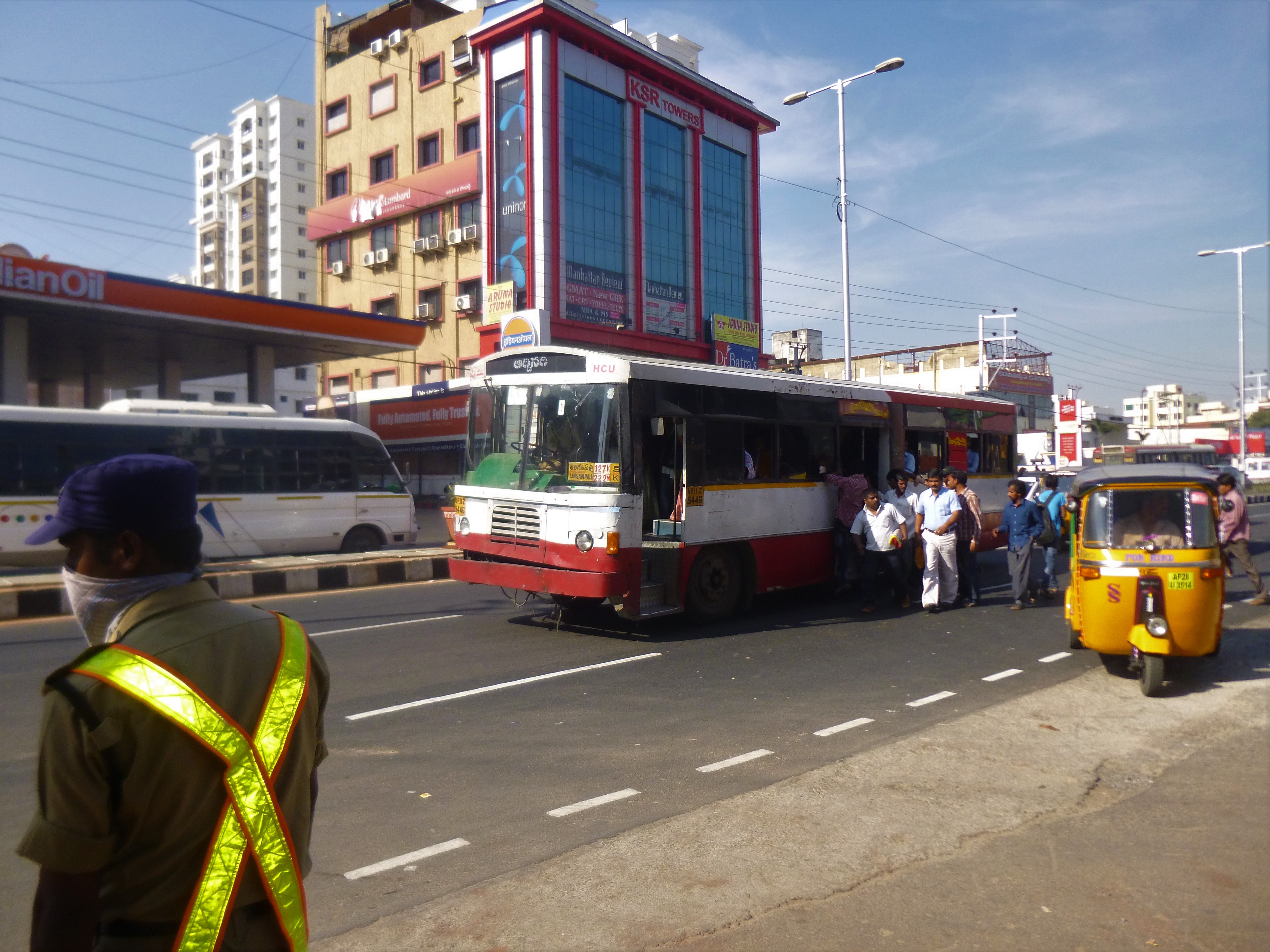
එවැනිම තවත් අපූරු දෙයක් වූයේ බස්නවත්වන හැටිය. මංතීරු තුනක් ඇති පාරේ මැද මංතීරුවේම බස් නවත්වනු දැකිය හැකිවිය. අයිනේ සිටි මගීන් පාර මැදට ගොස් බස්වලට ගොඩ වූ ආකාරය ද දැකිය හැකිවිය.

මං තීරු තුනක් ඇති පාරේ මැද තීරුවේ නැවැත්වූ බසයක්


බස් මගී ප්‍රවාහනය

අපට ප්‍රවාහන පහසුකම් සැපයුනේ නිශ්චිත ‌වේලාවලට බැවින් ඇතැම් අවස්ථාවල අපි පොදු බස්රථවල ගමන් කළෙමු. හයිදරාබාදයේ (මෙන්ම ආන්ද්‍රා ප්‍රදේශයේම) මගී බස් ධාවනය රජය සතු සමාගමක් වන 'ආන්ද්‍රා ප්‍රදේශ් රාජ්‍ය මාර්ග ප්‍රවාහන සංස්ථාව' (Andhra Pradesh State Road Transport Corporation) නම් එරට රජයට අයත් සමාගමයි (ලාංඡනය බලන්න). කෙසේ වෙතත් බස් වර්ග කීපයක් මෙන්ම ගාස්තු වර්ග කීපයක්ම වූ බව අපි දුටුවෙමු. නගරයේ ඉතා හොඳ බස් සේවාවක් විය. බස්රථවල පහසුකම් කෙසේ වෙතත්, නිතර බස් ධාවනය වන බව දැකිය හැකි විය. (පසුව 2014 දී මෙම සමාගම දෙකඩ වී අද වන විට තෙලන්ගානා ප්‍රාන්තය සඳහා වෙනම සමාගමක් ක්‍රියාත්මක වේ. මේ සමාගම් දෙකේම රජය සතු බස් රථ මෙන්ම පුද්ගලික අංශයෙන් කුලියට ගත් බස් රථ ද ධාවනය වේ.)

Andhra Pradesh State Road Transport Corporation ලාංඡනය


මෙට්‍රො එක්ස්ප්‍රස් යනු සීමිත නැවතුම් ඇති නගර අතර ධාවනය ‌වන බස් රථය 


මේ බස්වල බොහෝ දුරට අපට හමු වූයේ කඩදාසි ටිකට්පත්ය. අප ගමන් කළ කිසිදු බසයත ටිකට් මැෂින් දුටු බවක් මට මතක නැත (ඒ තත්ත්වය අද වන විට වෙනස් වී තිබිය හැකිය).

ටිකට් රඳවනයක්

මේ බස්වල නිකුත් කළ ටිකට්පත් කීපයක් මෙසේය. මේවායේ සඳහන් වන ලාංඡනය ඉහත සඳහන් කළ Andhra Pradesh State Road Transport Corporation ආයතනයේය.

බස් ටිකට්පත් කීපයක්. මෙහි සඳහන් ලාංඡනය උක්ත සමාගමේය.


මේ බස්වල කාන්තාවන් සඳහා අසුන් ගණනාවක් වෙන් කර තිබිණි. කෙසේ වෙතත්, ඒවායේ කාන්තාවන් මෙන්ම පිරිමි ද ගමන් කරනු දැකිය හැකි විය. බොහෝ විට බස්වල ආසන හිස්ව තිබූ නිසා එය ඒ තරම් ගැටලුවක් නොවීය. බස් රථ ද ඕනෑ තරම් විය.

කාන්තාවන් සඳහා වෙන්කළ අසුන්


පොත් කඩේට ගිය ගමන


මගේ ගමනේ දී මට මිල දී ගැනීමට තිබූ පොත් දෙකක් මිලට ගැනීමට Orient Blackswan නම් ප්‍රකාශන ආයතනය සොයාගෙන හයිද්‍රාබාද් නගරයේ අනෙක් කෙලවරටම ගියෙමි. ඒ ගමනට අපේ නඩයේ තවත් අය ද එක් වූහ. ඒ ගමන ගියේ තුන්රෝද රියකය. පොත්කඩවලට අමතරව රෙදි කඩවලට ද නගරය බැලීමට ද එය උපකාරී විය.
ඒ පොත් සාප්පුවේ කාර්යාලය ඇතුළත දර්ශනයක්

ඉන්දියානු ගමනට කලකට පෙර සිට මා ඔවුන් සමඟ සන්නිවේදනය කර තිබූ බැවින් අප එන බව ඔවුහු දැන උන්හ. ඒ නිසා ඔවුන් අපට සැලකුයේ හුදෙක් පොත් ගන්නට ආ අය ලෙස පමණක්ම නොවේ. ලංකාවෙන් පැමිණ ඔවුන්ගේ පොත් හල සොයා පැමිණීම ගැන ඔවුන් බෙහෙවින් සතුටූ බව ද දැකිය හැකි විය. අප උනන්දු වන විෂය පිළිබඳව දැනුවත්ව ඒ සම්බන්ධ අපේ රටට ද අදාළ පොත් මොනවාද කියා පෙන්වීමට ඔවුහු කටයුතු කළහ. එපමණක් නොව අපේ රටේ ප්‍රකාශන ආයතනයකින් ඉදහිට ලැබෙන ආකාරයේ මිල අඩුකිරීමක්ද අපට ඔවුන් වෙතින් ලැබිණි.


ඉන්ස්ටන්ට් ලෑන්ස්කේප්


අප සහභාගි වූ සමුළුව පැවතියේ හයිද්‍රාබාද් නගරයේ පිහිටි විශාල සම්මන්ත්‍රණ ශාලාවකය. එම ප්‍රදේශය ආසන්නයේ මෙන්ම, ප්‍රධාන මාර්ගයේ ඒ ආසන්න ප්‍රදේශයේද මග ‌දෙපස මෙන්ම, මාර්ගය මැද දූපත් කොටස් ද මලින් පිරුණු ලොකු කුඩා පැළවලින් පිරී ගොස් තිබිණි. ඒවාට වතුර දමා නඩත්තු කරන ආකාරය ද දැකිය හැකි විය. කෙසේ වෙතත් ඒ කුඩා මල්පැළ ඉතා මෑත දී සිටවූ බව නම් පෙනෙන්නට තිබිණි.

ඉන්ස්ටන්ට් බව පෙනුණු ලැන්ඩ්ස්කේප් එකක්
 
මේ මල්වගාව ගැන අපේ උදේ-හවස සාකච්ඡා අතර ඇති වූ මාතෘකාවක් වූයේ මේ 'ඉන්ස්ටන්ට් ලෑන්ඩ්ස්කේපින්'  ඉන්දියානුවන් ලංකාවෙන් ඉගෙන ගත්තේද, නැතිනම් ලාංකිකයන් ඉන්දියාවෙන් ඉගෙන ගත්තේ ද යන්නය. ඒ කාලයේ දී මෙවැනි වැඩ කළ අපේ නායකයන්ගේ නම් ගම් ද ඒ කතාවට එක් වූ බව සඳහන් කළ යුතුය.


ජලය හා විදුලිය


ඒ කාලයේ හයිදරාබාදයේ දිවා කාලයේ විදුලි කප්පාදුවක් වූ බවක් මතකය. එහෙත් සම්මන්ත්‍රණය තිබූ ප්‍රදේශයේ එවැනි ගැටලුවක් වූයේ නැත. එසේම ජලය පිළිබඳ අර්බුදයක් ද වූ බවක් පැහැදිලි විය. බොහෝ ගොඩනැගිලි හෝටල  ආදියට ජලය සහයන ලද්දේ බවුසර් මගිනි. කෙසේ වෙතත් ජලය අවශ්‍ය පරිදි සම්පාදනය කිරීමට හෝටල් බලධාරීන් පියවර ගෙන තිබිණි.

හෝටලයකට ජලය සපයන බවුසරයක්


ගෑණු ලමයි දැක්කම හිතුන දේ - ලංකාවට නිදහස ලැබෙද්දි ඉන්දියාවට එක් නොකළෙ ඇයි?

හයිද්‍රාබාද් නගරය ඉන්දියාවෙ ප්‍රධානම IT hub එකකි. ඒ රටේ විවිධ පෙදෙස්වලින් පැමිණි තරුණ තරුණියන් එහි රැකියාවල නියුක්ත වූ බව දැකිය හැකි වුණා. අප නවාතැන් ගත් හෝටලයට එන, රෑට කෑම කන්න ගිය තැන්වල රෑ 9-10ටත් පාරේ සිටි පිරිස් අතර තරුණ-තරුණියන් බොහෝය.
ඉන්දියාවේ ගෑණු ළමයි ලස්සනයි (ඇත්ත කියන්න එපායැ). ඉතින් දවස් ගණනක් තිස්සෙ මේ සුන්දර මුහුණු දකින අපේ කණ්ඩායමේ සමහරු හිටියෙ ටිකක් වශීවෙලා හෝ ටිකක් තක්බීර් වෙලා වගේ. වරක් අපේ කණ්ඩායමේ අයෙක් මෙහෙම කීවා...
"සුද්දො අපිට නිදහස දුන්න වෙලාවෙ, ඉන්දියාවට එකතු කළේ නැහැනෙ! එහෙනං අපිත් මෙහෙනෙ!"
ඔහු ඉන් අදහස් කළේ ලංකාව එදා ඉන්දියාවෙ කොටසක් උනානම් ලංකාවෙ අයට හයිද්‍රාබාද් හා වෙනත් ඉන්දියානු නගරවලට පහසුවෙන් යන්න අවස්ථාව ලැබෙන බවයි... ඒ හුදෙක් ලස්සන ගෑණු ළමයි නිසාම රටේ ස්වෛරීභාවය හා ස්වාධීනත්වය වචනයෙන් ‌හෝ පාවාදුන් මොහොතක් - හැබැයි විහිළුවට හා ඇති වූ දුක වහගන්න... මොකද එතැන අධිරාජ්‍ය විරෝධී වාමාංශිකයොත් හිටි නිසා!
(මේ කතාව මීට කලින් කියලා තිබ්බ එකක්.)


කියන්න බැරි කතා කීපයක් (මා විසින්ම) කපා හරින ලදි...

අදාළ මිත්‍රයන්ගේ ඉල්ලීම හේතුවෙන් මෙහි ලියන්නට බැරි කතා කීපයක් ඇති බව පමණක් මෙහි සඳහන් කරමි.‍ ඒත් ඒ සමහර කතා අපේ මිතුරන් හමුවන ඕපාදූප සැසිවාරවල දී කටගැසුම් ලෙස කියූ අවස්ථා ඇත. එහෙත් ඒ නම් ගම් රහිතවය (ඒ නිසා ඒ අය කලබල විය යුතු නැත). 


හයිදරාබාදයේ කියූ කතා (ලියු ලිපි)

1. Hyderabad The city, people and life, Nation, 04.11.2012

2. A different zoo and a village of culture at Hyderabad, The Nation, 11.11.2012

3. The Buddhist Heritage of Andhra Pradesh, The Nation, 25.11.2012


Thursday, January 7, 2021

යාපහුවෙන් ගල්ටැංවැවට ආ සිංහයෝ! (ගමන් කතා 5)


මං මුලින්ම ඉබ්බාගමුව - පොල්පිතිගම - මඩගල්ල පාරෙ ගියෙ 1990 ගණන්වල. ඉන්පස්සෙ 2006 මුලදි විතර ඒ පාරෙන් මඩගල්ල, මොරගොල්ලාගම, රැස්වෙහෙර හරහා අනුරාධපුරය දක්වා දිගු ගමනක් ගියා. ඊටත් මද කලකට පසු 2007-2008 කාලෙ අපි ඒ පැත්තෙ සෑහෙන ඇවිද්දා. ඒ හිරියාල හත්පත්තුවේ පරණ පන්සල් වගේම වෙනත් සුන්දර තැන් බලන්න. 

එහෙම ගිය ගමනකදි වරක් අපේ වාහනය ගල්ටැංවැව කියන හන්දියෙ පොඩි කඩේක නැවැත්තුවා තේ එකක් බොන්න. මේ හතරමං හන්දිය හැදෙන්නෙ ඉබ්බාගමුවේ සිට පොල්පිතිගම හරහා මඩගල්ලට යන ප්‍රධාන පාරට (B 159) තවත් පාරවල් දෙකක් සම්බන්ධ වීමෙන්. ඒ ප්‍රධාන පාර ඉබ්බාගමුව පැත්තෙ සිට ඇවිත් මේ හන්දියෙදි දකුණට හැරෙනවා. එතනදි කෙලින්ම යන පාර යාපහුව පැත්තට යන අතුරු පාරක්. වමට යන එක හිරිපිටියෙ සිට ගල්ටැංවැවට එන B 609 පාර. (ඒ අන්තිමට කී පාර අද නොවැදගත් නමුත්, අතීතයේ වැදගත් වූ පාරක්!)

ඉතිං එදා ගල්ටැංවැව හන්දියෙදි  මීට කලින් නුදුටු දසුනක් අපි දැක්කා. ඒ තමයි හංදිය මැද අඹපු සිංහ රූප කීපයක් තබා තිබෙනවා. යාපහුවෙ අකෘතියට කළ සිංහ රූප බව පැහැදිලිව පෙනුනා. දැන් ඒක වටරවුමක් වගෙයි. 

ඉතින් මම ඒ කඩේ හිටි අක්කාගෙන් ඇහුවා ඒ ගැන 

"මේ සිංහ රූප කොයි කාලෙ කරපු ඒවද?"

මේකට උත්තර දුන්නෙ කඩේ හිටපු ගමේ පොරක්.

"අම්මෝ මේවා රජකාලෙ ඉදල තියෙන්නෙ. යාපහු රාජධානි කාල‌ෙ..."

ඒ පොර හිතන්න ඇත්තෙ අපි බබ්බු කියලා. සමහරු නං එහෙම කිව්ව ගමන් පත්තරේටත් ලියනවා, ෆේස්බුක් දානවා. ඒවා ජනප්‍රවාදත් කියනවා. ඒත් ඊට මාස කීපයකට පෙර මේ හන්දියෙ තිබ්බෙ නැති එකක් දැන් තියෙන්නෙ කොහොමද කියලා හිතන්න අපට කල්පනාව තිබ්බා. (පොර වගේ උදෙන්ම දාල හිටියෙ නෑනෙ).  

මේ හන්දිය නවීකරණය කරල විවෘත කරලා තියෙන්නෙ 2006 ඔක්තෝබර් මාසෙ බව අපි එතන තිබ්බ පුවරුවක තියනවා පස්සෙ දැක්කා. ඒ පැත්ත අයත් වන්නෙ යාපහුව මැතිවරණ බලප්‍රදේශයට (ආසනයට).


මේ පින්තූර නං Google Street View  එකෙන්.

ධනේෂ් විසුම්පෙරුම

2021.01.07 

Friday, November 20, 2020

"නවගත්තේගමට තව දුරද?" (ගමන් කතා 4)


එදා අපි ගියේ පුත්තලම් දිස්ත්‍රික්කයේ පන්සල් හා වෙනත් පුරාවිද්‍යාත්මක ස්ථාන කීපයක් අධ්‍යයනයටය. එදා අපේ තෙදින ගමනක දෙවන දිනය විය. දිනය හරියටම කියන්නේ නම් 2006 අප්‍රේල් මස 10දාය.

පෙරදා නැවතී සිටි සංචාරක බංගලාවෙන් පිටත් ව විහාර දෙකක් පමණ අධ්‍යයනය කළ පසු අපේ ඊළඟ ඉලක්කය වූයේ නවගත්තේගමට යෑමය. අපේ කිසිවෙකුත් ඉන් පෙර නවගත්තේගමට ගොස් නොතිබූ අතර ඒ කෙබඳු ටවුමක්දැයි දැන සිටියේ ද නැත.

2006 වන විට ලංකාවේ ග්‍රාමීය මාර්ග පැවැති තත්ත්වය ඒ කාලය වන විට දැනුම් තේරුම් ඇති වයසේ සිටි ඇත්තෝ දනිති. එදා අපි ද මදක් දුෂ්කර වූ මාර්ගයක් දිගේ යනවා යනවා ඉවරයක් නැතිවා වාගේය. වරක් දෙවරක් පාරේ යන අයෙකුගෙන් මාර්ගය ඇසූ විට කී අයුරින් නවගත්තේමට එතරම් දුරක් නොවූ බව ද පෙනුණි. දැන් නවගත්තේගම ගැන දන්නා දේවල් කියා අවසන්ය. (ඒවාට විමලරත්න කුමාරගමගේ කවි මෙන්ම සයිමන් නවගත්තේගමගේ කතා ද ඇතුළත් විය). ඒත් තවමත් අපි නවගත්තේගමට පැමිණ නැත.

මෙසේ ගිය අප පිවිසියේ කලින් ගමන් කළ මාවතට වඩා ගෙවල් පිහිටා තිබූ ප්‍රදේශයකටය. දැන් අපට පැනයක් ඇති විය. ඒ පාර නවගත්තේගමට වැටෙන බව කී නමුත් මේ කුමන ප්‍රදේශයක්ද යන්නය. කිසිදු බෝඩ් එකක් හෝ මං සලකුණක් ද නැත.

ඒ නිසා අපි කෙනෙකුගෙන් පාර විමසීමට සිතීමු. වාහනයේ වේගය අඩු කරන්නට කියා ඉදිරි අසුනේ මම මෙසේ ඇසුවේ පාරේ ගිය වැඩිහිටියෙකුගෙනි.


"අන්කල්, නවගත්තේගමට තව දුරද?"

(ඒ කාලේ ඒ මහතාට අන්කල් කීමට තරම් මම තරුණ වූ බව මෙහිිදී සඳහන් කළ යුතුය. එකල මගේ කොණ්ඩය ද තනිකරම කළු පාටය).

මා දෙසත්, වාහනයේ උන් අනෙක් අය දෙසත් මොහොතක් බලා සිටි ඔහු මෙසේ කීවේය.

"මේ නවගත්තේගම තමයි මහත්තයො!"

මටත්, කාටත් උත්තර නැති විය. "ස්තුතියි" කියා මදක් ඉදිරියට ගිය අපේ සිනාව පිටවූයේ ඔහුව අපට නොපෙනී ගිය පසුවය. මොනවා උනත් මේ කතාවේ වගකීම හැමෝම බාරගත් බව නොකියා බැරිය.

මේ තාමත් එදා ඒ ගමන ගිය අපේ කට්ටිය නිතර මතක් කරන කතාවකි.

(ගුවන් ඡායාරූපය Google Earth වෙතින් ලබාගන්නා ලදි. 2009 වර්ෂයේ එකකි)

ධනේෂ් විසුම්පෙරුම

2020.11.20

Thursday, September 24, 2020

වවුනියාවේ මුහුද (ගමන් කතා 2)

මේක එක්තරා ආකාරයක වෘත්තීය ගමනක් අතර සිද්ධ වෙච්ච දෙයක්. එක්තරා රාජ්‍ය නොවන ආයතනයකින් දියත් කළ තරුණ පුහුණු වැඩසටහන් මාලාවක අවසානයේ ඒ පුහුණුලාභීන් කීප දෙනෙකු හමුවී සාකච්ඡා කර ඔවුන්ගේ පුහුණුව ගැන හා ඒ නිසා ජීවිතය වෙනස් වූ ආකාරය ඒවායේ සාර්ථක කතා එකතුවක් සකස් කිරීමටයි මට තිබුණේ. මේ 2010 හෝ 2011 පමණ.

අපි ගියේ වවුනියාවටයි. අපි ගිය ගමනට ඒ ආයතනයේ ප්‍රධාන කාර්යාලයේ සේවය කරන තරුණියන් දෙදෙනකු ද සම්බන්ධ වුණා. ඉතින් අපි කාර්යාලයට ගිහින් මමත් ඒ ආයතනයේ නිලධාරියෙකුත් පුහුණු වූ තරුණ තරුණියන් හමුවන්න අදාළ ගම් කීපයකට යන්න කියලා සූදානම් වුණා. ඒ අතරෙ අර ප්‍රධාන කාර්යාලෙන් ආ තරුණියන් දෙදෙනාට කරන්න දෙයක් තිබ්බෙ නෑ. ඔවුන් වවුනියා කාර්යාලයේ ඔවුන් දන්නා අඳුනන අය සමඟ ඇවිදින්න යන තැන් කීපයක් ගැන කතා කළා.

එහිදී එක් තරුණියක් මෙහෙම ඇහුවා... "මෙහෙ බීච් එක තියෙන්නෙ කොහෙද?"

ඒකට කට්ටියම හිනා උනා. ඒ වන විට වයස විසි ගණනක සිටි ඇය ලංකා සිතියමේ වව්නියාව ඇති තැන ඇය දැන සිටියෙ නැති බවයි පෙනුණේ... මට මතක හැටියට මහනුවර කිට්ටුව පදිංචිව සිටි ඈ කළේ ගිණුම් තැබීමයි. ඒත් කොහොමහරි අපි ගම් කීපයක ඇවිදලා හවස ආපහු එන අතරෙදි, වව්නියා කාර්යාලය අය අර තරුණියන් දෙදෙනාට මුහුද පෙන්නන්න අල්ලපු දිස්ත්‍රික්කෙ වන මන්නාරමේ කෙලවරට එක්කගෙන ගිහින් තිබ්බා!

ධනේෂ් විසුම්පෙරුම

2020.09.24

Thursday, September 10, 2020

ස්ථාවර වූ ජංගමය! (ගමන් කතා 1)

(ගමන් කතා කීවෙ අපි ඔය ට්‍රිප් යනකොට වූ සිද්ධිවල එකතුවක්)


ඔන්න මේක උනේ අපි මාසෙකට ට්‍රිප් දෙකක් විතර යන කාලෙ. එදා අපි කීප දෙනෙක් ගියා වාරණ පන්සලට. ගිහින් එහි තිබූ පැරණි දේවල් විස්තර බලලා ඒ කිට්ටුව කඩේකින් බනිස් කාල තේ බීලා ආපසු ආවා තිහාරිය හන්දියට. එතැනින් ඊළඟට යන්න තිබ්බ තැනට යන එක ගැන කතා කර කර ඉදිරියට යද්දි අපේ නඩේ හිටපු වැඩිහිටියා පේන්න නෑ. (වැඩිහිටියා කීවට මට වඩා අවුරුදු හතරයි නැත්තං පහයි වැඩිමල්.)

හැරිලා බලද්දි එයා පාර අයිනට වෙලා නැවතිලා. බැලින්නං එයාගෙ ජංගම දුරකථනයට කෝල් එකක් ඇවිල්ලා. ඉතිං එයා ගමන නතර කරලා, පාරෙන් ඉවතට හැරිලා කෝල් එකට ආන්සර් කරනවා. අනිත් එවුන් ගමන යනවා.

මේක දැකපු අපේ එකෙක් කිව්වා "ඕක මොබයිල් එකක් ද එහෙම නැත්තං ලෑන්ඩ් ෆෝන් එකක්ද බං" කියලා.

අපේ යාලුවාටත් එතකොට තමයි මතක් උනේ යන ගමන් කතා කරන්න පුළුවන් කියලා. ඒ මිත්‍රයා දැන් නං යන ගමං ආන්සර් කරනවා. ඒ මදිවට බයික් එකේ යන ගමනුත් ආන්සර් කරනවා. 
 

ධනේෂ් විසුම්පෙරුම
2020.09.10

Monday, June 29, 2015

Totagamuwa Rajamaha Vihara: Glimpse from the past

By Dhanesh Wisumperuma

Photos: Bushana Kalhara

The Nation, June 20, 2015, Insight, p.

The Nation: http://nation.lk/online/2015/06/20/totagamuwa-rajamaha-vihara/
My Blog: http://dhaneshw.blogspot.com/2015/06/totagamuwa-rajamaha-vihara.html


New image house or aluth vihare

We turned left from the Galle Road at Telwatta Junction and proceeded along a narrow road leading towards Kiralagahawela. After crossing the Colombo-Matara railway line, we reached our destination – Totagamu Purana Ranpath Rajamaha Vihara, Telwatta. This temple is situated in the village of Telwatta in Galle District, and is in Vellboda Pattuwa as per the old division system. The temple is sometimes mentioned as Telwatta temple as it is situated in that village. Present day Totagamuwa is a village, south to Telwatta.

The temple in front of us was on a flat terrain, and it contained a quadrangular-shaped terrace, surrounded by a low wall or rampart with few gates. All sacred sites of the temple – the stupe, bo tree and image houses – were located inside this quadrangle and the dwelling houses of monks and other associated buildings were situated outside.
Totagamuwa Temple has a rich history and contains several archaeologically-important monuments, which was the aim of our visit to the temple.The bo tree

History in brief

The history of Totagamuwa Temple dates at least to late Anuradhapura period. The inscriptions with Sinhala letters dated to a period 8th to 11th centuries are found on few pillars remaining in the temple premises adjoining the devalas. These inscriptions denote the devotee who devoted those pillars, which are what is remaining from a building that stood within the present temple premises. Although the folklore on the origin of the temple can predate this date, this appears to be the oldest verifiable date of the temple.
Titthagama Vihara mentioned in the Mahavamsa is identified as the present Totagamuwa Temple. The first reference in history is to the King Vijayabahu the great, who built a building in Titthagama Vihara. Titthagama is the Pali version of the name Totagamuwa, which literary means ‘the village containing a fort or a port’. The kings of Polonnaruwa, Dambadeniya, Kurunegala and Kotte Kingdoms have constructed various buildings, and supported the temple as mentioned in our chronicles. Vijayaba Pirivena is one such institution started during this time.The temple reached its zenith by the time of Kotte Kingdom, as a temple as well as an education institute. The temple is being described in four sandesa kavyas(messenger poems) – Tisara, Parevi, Kovul and Girasandesas. These poetic descriptions include accounts of the temple’ stupa, bo tree, image house and monks, while the pirivena and its activities are also described some of these poems.

Meanwhile, Girasandesa is written to send a message to the incumbent of this temple, who was the most notable and eminent monk to reside in this temple. He was none other than Ven. Totagamuwe Sri Rahula Thera, well-known scholarly monk of the 15th century, who authored several books and who was fluent in several languages.The state of the temple as well as the monk is elaborated in Girasandesa.

This temple flourished until the end of the 16th century, and was destroyed by the Portuguese, who launched a campaign against the Buddhist temples in the maritime areas of the country under their control. The ill-reputed campaign of Thome de Souza in 1580 destroyed several famous temples along the coastal belt and the description of this campaign includes a reference of destroying two pagodas in Madampe. It is believed that this includes Totagamuwa, as Madampe is a village located to north of Telwatta. Being a well-known and much-venerated temple located close to the coast, it is impossible to think that the Portuguese excluded this from their devastation.An inscription of late Anuradhapura period

Revival and current state

After the period of decline for few centuries, the revival of the temple was initiated during the mid-18th century, when the area was under the Dutch rule. A monk from the southern region, Ven.Pallatara Punnasara Thera, who received his higher ordination from Kandyan Kingdom was responsible for the revival of this temple in late 18th century. The current lineage of monks was commenced by this monk, and continues upto today with three distinct branches.

As mentioned above, the key religious edifices of archaeological importance are situated in the inner quadrangle. The bo tree, located close to the southern wall, is large and old and probably saved from destruction. The stupa is located in the northern corner of the premises. The two image houses, old and the new one are among the most important edifices of archaeological importance, except the pillars with inscriptions, located near the two devala buildings.

Meanwhile, there are many other edifices in the temple belonged to the 19th century or later. For instance, the belfry dates back to 1881, and the preaching hall or the Dharmasala dates to the early 20th century. There are two devale buildings in the eastern side of the quadrangle, a Visnu Devale and Tun Devale.Pancanarighata under the Makara Torana in new image house

Image houses and paintings


The parana vihare or the old image house is said to be completed in 1799 along with the revival of the temple. It contains three Buddha images and some paintings most probably dating to the period the temple was constructed. The paintings in the inner chamber seem to be older than the vestibule of the image house and common paintings such as jataka stories, like mara parajaya (the defeat of Mara).

The aluth vihare or the new image house was completed in 1805, as per the inscription above one of the inner doorways. The inner chamber contains three Buddha statues in three postures and a statue of God Vishnu. The paintings in the inner chamber and the vestibule of the image house are some of the classic works of low country art, follows the Kandyan tradition. The subject matter of these paintings is mostly the common themes used in Kandyan tradition paintings. For instance, the life events of the Buddha, such as mara parajaya, sat satiya (episodes of the seven weeks after the enlightenment) are found among paintings. Also jataka stories (stories from Buddha’s previous births) like Vessantara Jataka, Sama Jataka, Culla Dhamma pala Jataka, Sasa Jataka and Devadhamma Jataka and suvisivivarana (twenty-four proclamations) are among the paintings. Also solos mahastana (16 places of worship in Sri Lanka) are found on the walls.The statue of Kamadewa or Mara or Ananga in new image house

There are some rare and possibly unique elements among the paintings and murals. The prominent statue between the two inner doors is identified as Kamadeva(Mara) or Ananga bearing the bow is said to be unique to Totagamuwa. The elaborative display of six heavens is not seen in such descriptions while painting of five footprints of the Buddha is also said to found only in Totagamuwa. The painter as identified as Hat Korale Sittara Muhandiram. The details in paintings and the color usage of these paintings confirm the talent of the painter, and these have been cured recently by the Department of Archeology. There is a clear European influence in some of these paintings. For instance, the shape of the vase of pancanarighata painting and two figures that support the vase show such influence. Some decorative items and floral displays also show such an influence.

The date of the paintings in the new image house is a matter of disagreement. Renowned artist and art historian, LTP Manju Sri dates these paintings to 1805, based on the date of the construction of the image house. However Prof. Senaka Bandaranayake argued that these paintings are more likely to belong to mid-19th century. The presence of European influence supports this argument, with which fact we can agree with.Pillars with inscriptions


http://nation.lk/online/2015/06/20/totagamuwa-rajamaha-vihara/

Saturday, April 11, 2015

Rare landscape of Ussangoda

Dhanesh Wisumperuma
The Nation, 11-04-2015 (Insight, p. i 10)

http://www.nation.lk/edition/insight/item/39844-rare-landscape-of-ussangoda.html

Pics by Bushana Kalhara


After turning off a small road to the right near Nonagama Junction on Colombo-Hambantota (A2) road, we proceeded few hundred meters and then turned to the right hand side again and there was our destination. We were in the middle of a rare and unusual landscape of the country, known as Ussangoda.

Anyone would be able to see the difference of the open landscape in front of us in contrast to the surrounding area, which comprised mostly of dry zone vegetation. The soil of the area was deep red in color and quite an extensive area was almost devoid of any tall vegetation, except in few small patches that contained small shrubs. We were amazed by the scenery, while walking across the flat landscape in a southerly direction. The area is a rock outcrop significantly higher from the sea level, which is evident from the southern end where a narrow path taperes down towards the sea shore. This landmass was unusual and unique in the southern coastal belt of the country, a fact that is apparent to any visitor to the place. The Ussangoda rock outcrop is situated within the Ambalantota Divisional Secretariat Division in the Hambantota district in the Southern Province of Sri Lanka. To the west of it was the Lunawa Kalapuwa, a lagoon, and Kalametiya Sanctuary. Lunawa, Kalametiya, Nonagama and Welipatanwila are among the villages situated close by.

Usangoda or Ussangoda

The name of the area was pronounced as ‘Usangoda’, as evident in Nila Kobo Sandesaya, a 18th century sandeshakawya(messenger poem). This poem was written with the objective of carrying a message to the god Kataragama and the messenger bird flew across this area. It mentioned the place as Usangoda, which could be the original name which changed to the easily pronounceable from Ussangoda better known today. The poet instructed the bird to look at the soil which was in red color resembling the flesh of humans that was piled up by a group of non-humans or demons that came from the ocean to encroach the land. The poet also likened the color of the soil to a type of red colored flower, rakthakusuma, which could be the rathmal. It is worthy to note that the poet who lived two centuries ago was aware of the color of the soil of this place. However, he didn’t want to comment how the red color originated.

The rock outcrop is a high rising ground from the sea shore and the name may have been originated from that sense – the higher ground area. The recorded name ‘Usangoda’ supports this. It is still used by many.

As we were aware, there are many folk stories coined to explain the origin of the color and the lack of vegetation on the landscape, some of which are undoubtedly of very recent origin. One story mentions that this was the place where betel was first brought to Sri Lanka and the color of the soil was a result of deposition of masticated betel! Another story goes on to say that it was a ground of the local deity Mangara. A third story links this place to Ravana, a character of the Indian epic poem of Valmiki, considered as a mythical one by the learned people. There will be such folk stories generated in future too, due to the creativity of the people, and not based on facts. There is a suggestion that this is where a meteor knocked the earth in the past.
However this unusual nature of Ussangoda rock outcrop is explained by science.

Serpentine rock

Ussangoda is an outcrop of a rock type known as ‘serpentine rocks’, which is a rare formation in Sri Lanka. According to geologists, serpentine bodies are naturally found in the vicinity of the boundary of Highland and Vijayan Complex, two geological plates that make the country. Availability of serpentine rocks in Sri Lanka was not known to science until 1970s, when geological explorations revealed the availability of such sites along the boundary of the two plates. There are six serpentine rock formations found in the country–other sites being Yudhaganawa (in Wasgomuwa), Indikilapelessa, Ginigalpelessa, Katupotha and Rupaha, all of which are situated along the boundary of the plates.

These serpentine bodies and soils associated with them contain high concentrations of heavy metals such as nickel, cobalt, iron and magnesium. There are iron oxide and silicon dioxide as major components of the soil. It is these heavy metals that limit the growth of vegetation on the surface of these bodies as it alters the physical and chemical nature of soil. Plants that can tolerate the heavy metal concentration are able to establish themselves in this extreme environment. Researchers have found high concentrations of heavy metals in the few species of plants which grow on such places. This vegetation is often known as serpentine flora and includes a few dozens of species that fascinate many scientists by their remarkable ability to thrive on this type of soils.

The vegetation of the serpentine Ussangoda area contains of two distinct forms of vegetation - dominant prostrate species (plants that grow lying along the ground) and few patches of thorny shrubs. There is a number of research papers conducted on the vegetation of Ussangoda and other serpentine rocks.

Due to this particular ecological significance, and due the proximity to the other important habitats in the surrounding area, an area comprising 349 hectares (i.e. 862 acres) was declared as the Ussangoda National Park under the Flora and Fauna Ordinance in May 2010. We noticed the possible tracks of driving vehicles through this landscape, which can cause degradation of the site.

Time has passed and the evening sun was going down the western sky. It was time to say goodbye to this extraordinary place. On our return we had a locally made fruit drink made of the fruits of kadol, a mangrove plant, and sold by the villagers in the small thatched huts – they are receiving some income from the tourists that visit the area. We left the place while keeping this in mind - it is our duty to protect this place, even from misinterpretations.


The unusual landscape of reddish earth


Small rock found on the flat land


A low-lying plant that flourish on the landscape

http://www.nation.lk/edition/insight/item/39844-rare-landscape-of-ussangoda.html

Monday, March 30, 2015

ශී‍්‍ර ලංකාවේ උද්භිද උද්‍යාන නව මාවතකට

ශී‍්‍ර ලංකාවේ උද්භිද උද්‍යාන නව මාවතකට

ධනේෂ් විසුම්පෙරුම

විදුසර 2015-03-11 (Vidusara) - Not available online

ඡායාරූප: භූෂණ කල්හාර


උද්භිද උද්‍යානයක් කී පමණින් බොහෝ දෙනාගේ සිතට නැගෙන්නේ විසිතුරු මල් හා වෙනත් ශාකවලින් පිරුණු අලංකාර උද්‍යානයකි. මේ නිසා පොදු ව්‍යවහාරයේදී මෙවැනි උද්‍යාන හඳුන්වනු ලැබෙන්නේ මල්වත්ත යනුවෙනි. මේ හේතුවෙන් උද්භිද උද්‍යාන යනු දේශිය මෙන්ම විදේශීය සංචාරකයන්ගේ සිත් ගත් ස්ථාන වේ.

ඈත අතීතයේ පටන් අපේ රටේ මෙවැනි මල්වතු පැවති බවට සැලකිය යුතු සාධක තිබේ. කෙසේ වෙතත් නූතන අර්ථයෙන් යුක්තව පොදු උද්භිද උද්‍යාන ආරම්භ වන්නේ 19වන සියවස ආරම්භයේදී පමණය. මෙරට පහතරට ප‍්‍රදේශ පාලනය කළ බි‍්‍රතාන්‍ය ජාතිකයන් 1810 වර්ෂයේදී පමණ කොළඹ නගරයේ වර්තමාන කොම්පඤ්ඤවීදිය ප‍්‍රදේශයේ ‘කිව් උද්‍යානය’ නමින් උද්භිද උද්‍යානයක් ආරම්භ කරන ලදී. එය පිහිටුවීම සඳහා එවකට බි‍්‍රතාන්‍යයේ විසූ ජෝසප් බෑන්ක්ස් නම් ප‍්‍රකට විද්‍යාඥයාගේ උපදේශය හා විශේෂ උනන්දුව හේතු විය. එහි එක් අරමුණක් වූයේ යටත්විජිතයක් වූ ලංකාවේ වෘක්ෂලතාදිය හා සම්පත් ආර්ථික වශයෙක් උපයෝගි කරගත හැකි ආකාරය පිළිබඳ සොයා බැලීමය. 1813 වර්ෂයේදී පමණ මේ උද්‍යානය කළුතර උග්ගල්බඩ ප‍්‍රදේශයට ගෙන යන ලදි. යළිත් 1821 වර්ෂයේදී මේ උද්භිද උද්‍යානය, වඩා යෝග්‍ය දේශගුණයක් පැවැති මහනුවර ආසන්නයේ පිහිටා ඇති පේරාදෙණිය වෙත ගෙන යන ලද අතර, එය අද වන විට මෙරට ප‍්‍රමුඛතම උද්‍යානය ලෙස ‘පේරාදෙණිය රාජකීය උද්භිද උද්‍යානය’ ලෙස ප‍්‍රකටය.

මේ අතර 1861 වර්ෂයේදී නුවරඑළිය දිස්ත‍්‍රික්කයේ හක්ගල උද්භිද උද්‍යානය ආරම්භ කරනු ලබන්නේ ආර්ථික භෝගයක් ලෙස මෙරට වගා කිරීම ආරම්භ කළ සින්කෝනා වගාව පිළිබඳ පර්යේෂණ පැවැත්වීම සඳහාය. එ් ආකාරයෙන්ම රබර් වගාව ශ‍්‍රී ලංකාවට හඳුන්වාදීමත් සමඟ, රබර් පිළිබඳ පර්යේෂණ සිදු කළ වර්තමාන ගම්පහ දිස්ත‍්‍රික්කයේ හෙනරත්ගොඩ ප‍්‍රදේශයේ 1876 වර්ෂයේදී උද්භිද උද්‍යානයක් පිහිටුවන ලදි. එදායින් පසුව ගත වූ කාලය ඇතුළත බදුල්ල, නුවරඑළිය හා අනුරාධපුර වැනි ස්ථාන කිහිපයක උද්භිද උද්‍යාන පිහිටුවන ලද නමුත් විවිධ හේතු නිසා එ්වා පසු කලක අත්හැර දමා තිබේ.

වර්තමානයේ මෙරට උද්භිද උද්‍යාන පාලනය කරනු ලබන්නේ උද්භිද උද්‍යාන දෙපාර්තමේන්තුව විසිනි. ආරම්භයේ සිට 19වන සියවස පුරා රජයේ ස්වාධීන දෙපාර්තමේන්තුවක්ව පැවැති එය, 1912දී කෘෂිකර්ම දෙපාර්තමේන්තුව පිහිටුවීමත් සමඟ එය යටතට පත් විය. ඉන්පසුව, යළිත් 2006 වර්ෂයේදී උද්භිද උද්‍යාන දෙපාර්තමේන්තුව ස්වාධීන දෙපාර්තමේන්තුවක් බවට පත් විය.


උද්භිද උද්‍යානවල කාර්යභාරය

උද්භිද උද්‍යානවල මූලික කාර්ය භාරය වන්නේ ඇතැම් විට සාමාන්‍ය ජනතාව විශ්වාස කරන පරිදි හුදෙක් සෞන්දර්යාත්මක වින්දනයක් හා විනෝදාස්වාදයක් ලබාදෙන මල්වත්තක් සේ ක‍්‍රියා කිරීම නොවේ. මේ උද්‍යානවල කාර්යභාරය පිළිබඳව බොහෝ උගතුන් හා විද්‍යාඥයින් අතර පවා ප‍්‍රාමාණික අවබෝධයක් නොමැත. මේවාට වඩා වැදගත් වූ විද්‍යාත්මක කාර්යභාරයක් තිබේ.

උද්භිද උද්‍යානවල ඇති ප‍්‍රධානතම වැදගත්කම වන්නේ විතැන් සංරක්ෂණය සඳහා එ්වා දක්වන දායකත්වයයි. එමගින් ශාක ජෛව විවිධත්වය ආරක්ෂා කිරීමේලා ඉතා වැදගත් ප‍්‍රයෝජනයක් සැලසේ.

ශාක පිළිබඳ පර්යේෂණ පැවැත්වීමේදී වැදගත් කාර්යයක් උද්‍යානවලින් සිදුවේ. නිදසුනක් ලෙස ගතහොත් විද්‍යාත්මක පර්යේෂණ සඳහා වැදගත් වන ශාකාගාර නිදර්ශක එකතුවක් අපේ පේරාදෙණිය උද්භිද උද්‍යානයේ පිහිටා ඇති ශාකාගාරය සතුව තිබේ. එහි ඇති නිදර්ශක එකතුව 168,000ක් පමණ වේ. මේවා ශාක පිළිබඳ පර්යේෂණ කරන්නන්ට නැතිවම බැරි එකතුවකි.

සුවිශේෂ අධ්‍යාපනික වැදගත්කමක්ද මේ උද්භිද උද්‍යාන සතුව පවතී. එ් විවිධ මට්ටම්වල සිසුන්ට ශාක හා සම්බන්ධ දැනුම ලබාදීම සඳහාය.

ආර්ථික වශයෙන් වැදගත් කටයුතු කිහිපයක්ද මේ උද්‍යාන හරහා ක‍්‍රියාත්මක වන අතර, එ් අතර ආශ‍්‍රිතව මල් හා විසිතුරු පැළ වගාකිරීම මෙන්ම ඔසු පැළ වගාකිරීම වැනි වැඩසටහන් ආදිය ඇතුළත්ය. උද්භිද උද්‍යානවලින් සංචාරක කර්මාන්තයට ප‍්‍රයෝජනයක් සැලසෙන බව අමුතුවෙන් කිවයුතු නොවේ. එය අදාළ ප‍්‍රදේශයේ මෙන්ම රටේ ආර්ථිකයටද ප‍්‍රයෝජනවත්ය.

කෙසේ වෙතත් උද්භිද උද්‍යානවලින් සැලෙසන ඉතා වැදගත් කාර්යය වන්නේ විතැන් සංරක්ෂණයේලා මේ උද්‍යානවලින් ලබාගත හැකි දායකත්වයයි.


විතැන් සංරක්ෂණයේලා උද්භිද උද්‍යානවල වැදගත්කම

විතැන් සංරක්ෂණය (ex situ conservation) යනුවෙන් හඳුන්වනු ලබන්නේ කිසියම් ජීවියකුගේ ජනක ප්ලාස්මය (germplasm) එම විශේෂයේ ස්වාභාවික වාසස්ථානයෙන් බාහිරව සංරක්ෂණය කිරීමයි. ශාක සම්බන්ධයෙන් නම්, මෙහිදී අදාළ ශාකය ලෙසට, බීජ ලෙස, පරාග ලෙස, පටක ආදි ලෙස වෙනත් ආකාරවලින්ද සිදුකරන ආරක්ෂා කිරීමට හැකිය. මේවා එකතු කිරීම, පාලනය කිරීම වැනි කාර්යයන් රාශියක් උද්භිද උද්‍යානයක් මගින් සිදු වේ.

විතැන් සංරක්ෂණය මගින් ලබා ගත හැකි ප‍්‍රයෝජන රාශියකි. නිදසුනක් ලෙස, මේ වන විටද වඳ වී යාමේ තර්ජනයට ලක්ව ඇති ශාක විශේෂ ආරක්ෂා කිරීමට අවස්ථාවක් එමගින් ලැබේ. විවිධ හේතු නිසා වඳවී යා හැකි ශාක විශේෂ ගණනාවක් උද්භිද උද්‍යානවලද වගා කර තිබේ. මෙවැනි එකතු මගින් ලබාගත් බීජ හෝ වෙනත් රෝපණ ද්‍රව්‍ය යොදාගනිමින් එම ශාක විශේෂ යළිත් ස්වාභාවික පරිසරයට හඳුන්වා දුන් අවස්ථා වාර්තා වී තිබේ.

නිදසුනක් ලෙස ගතහොත් 2012 වර්ෂයේදී ප‍්‍රකාශයට පත් කළ ශ‍්‍රී ලංකාවේ තර්ජනයට ලක් වූ සත්ත්ව හා ශාක පිළිබඳ රතු ලේඛනයට (Red List of Threatened Fauna and Flora of Sri Lanka) අනුව මෙරට හමුවන ශාක විශේෂ 3,154ක ප‍්‍රමාණය අතරින් ශාක විශේෂ 1,386ක් පමණ ප‍්‍රමාණයක් තර්ජනයට ලක්ව ඇත. මේ අතරින් ශාක විශේෂ 177ක් පමණ ප‍්‍රමාණයක් දැඩි ලෙස අන්තරායක (Critically Endangered - CR) තත්ත්වයේ ලා සැලකේ. මෑත කාලයේදී හමු වී නොමැති මේ ශාක සමහරක් අද වන විට වඳ වී ගොස් තිබිය හැකිය. මේවා ආරක්ෂා කිරීමට හා වගා කිරීමට උද්භිද උද්‍යානවලට විශේෂ කාර්යභාරයක් සිදු කළ හැකිය. නිදසුනක් ලෙස ගතහොත්, කළුතර දිස්ත‍්‍රික්කයේ වලව්වත්ත නම් විශේෂිත පරිසර පද්ධතියක හමුවන දැඩි ලෙස තර්ජනයට පත් ශාක විශේෂයක් වන Mesua stylosa ශාක උද්භිද උද්‍යානවල වගා කර තිබේ.

මෙරට ශාක අතරින් ස්වාභාවික පරිසරයෙන් වඳවී ගොස් ඇති (Extinct in wild) බව සැලකෙන ශාක විශේෂ දෙකක් මේ වන විට දැකිය හැක්කේ මෙරට උද්භිද උද්‍යානවල පමණි. නිදසුනක් ලෙස ගතහොත් Alphonsea hortensis හා Doona ovalifolia යන මේ අප රටට ආවේණික ශාක දෙක ස්වාභාවික පරිසරයේ දැකිය නොහැකි අතර, එ්වා හමුවන්නේ උද්භිද උද්‍යානවල පමණි. අනාගතයේදී මෙවැනි ශාක ස්වාභාවික පරසරයේ වගා කිරීමට හැකියාව ලැබීමට යම් අවස්ථාවක් ලැබෙන්නේ මේ සංරක්ෂණ උත්සාහය නිසාය.

මේ විතැන් සංරක්ෂණයේදී විවිධ පර්යේෂණ සඳහා ලබා ගැනීමට අවශ්‍ය පටක හා ශාක ආදි කොටස් ලබාගැනීමට හැකිය. ඇතැම් අවස්ථාවලදී ස්වාභාවික පරිසරයෙන් ශාක කොටස් ලබාගැනීම නිසා ඇති විය හැකි තර්ජනය අඩු කිරීම සඳහාද මේ විතැන් සංරක්ෂණයෙන් ලබාගන්නා ජනක ප්ලාස්ම ප‍්‍රයෝජනවත් වේ. එසේම ශාක විශේෂවල බීජ ආදිය කල් තබාගැනීම අපහසු අවස්ථාවලදී එ්වා වර්ධනය කිරීමට අවස්ථාව සැලසීමට උද්භිද උද්‍යාන ප‍්‍රයෝජනවත් වේ.

මෑතක් වනතුරුම සංරක්ෂණයේලා අපේ රටේ උද්භිද උද්‍යානවලින් සිදු වූ සංරක්ෂණ දායකත්වය තරමක් අඩුය. එහෙත් මෑතක සිට අපේ රටේ එ් පිළිබඳ වැඩි අවධානයක් යොමු වී ඇත. විශේෂයෙන් 2006 වර්ෂයේදී උද්භිද උද්‍යාන දෙපාර්තමේන්තුව පිහිටුවීමේදී එහි කාර්යයන් අතරට මේ විතැන් සංරක්ෂණ ක‍්‍රමවේද සඳහා සැලසුම් සකස් කිරීම හා එ්වා ක‍්‍රියාවට නැංවීම අයත් වේ.

විවිධ භූ දේශගුණික කලාපවල උද්භිද උද්‍යාන පිහිටුවීම වැදගත් වන්නේ මේ සංරක්ෂණ වැදගත්කම නිසාය. අදාළ දේශගුණික කලාපයේ දැකිය හැකි ශාක විශේෂ ආරක්ෂා කිරීමේදී එම කලාපයේම පිහිටුවනු ලබන උද්භිද උද්‍යාන මගින් මහඟු සේවයක් සැලසේ. මෑත කාලයේදී ශ‍්‍රී ලංකාවේ ආරම්භ කිරීමට යෙදුණු උද්භිද උද්‍යාන දෙකක් මේ කාර්යය සඳහා විශේෂ අවධානයක් යොමුකර ඇත. එ් මිරිජ්ජවිල ප‍්‍රදේශයේ පිහිටා ඇති වියළි කලාපීය උද්භිද උද්‍යානය හා අවිස්සාවේල්ලට නුදුරු ඉලූක් ඕවිට ප‍්‍රදේශයේ පිහිටා ඇති සීතාවක තෙත් කලාපීය උද්භිද උද්‍යානයයි. (සටහන් බලන්න)


සටහන 1 - වියළි කලාපීය උද්භිද උද්‍යානය - මිරිජ්ජවිල


හම්බන්තොට දිස්ත‍්‍රික්කයේ, හම්බන්තොට නගරයට නුදුරුව මිරිජ්ජවිල ප‍්‍රදේශයේ පිහිටා ඇති වියළි කලාපීය උද්භිද උද්‍යානය මහජනතාව වෙනුවෙන් විවෘත කරන ලද්දේ 2013 වර්ෂයේ නොවැම්බර් මාසයේදීය. එය මෙරට වියළි කලාපයේ පිහිටා ඇති එකම උද්භිද උද්‍යානය වේ.

අක්කර 300ක පමණ භූමියක් පුරා පිහිටා ඇති මේ උද්‍යානය පිහිටුවීමට පෙර මේ ප‍්‍රදේශය හේන් වගාව සඳහා යොදාගෙන තිබේ. දශක කිහිපයකට පෙර මේ ආශ‍්‍රිත ප‍්‍රදේශයේ කජු වගා කිරීමට හා වන වගාවක් ඇති කිරීමට රජය උත්සාහ දරා ඇතත් එය අසාර්ථක වී තිබේ. මේ සඳහා එක් හේතුවක් වී ඇත්තේ මේ ප‍්‍රදේශයේ පවත්නා දැඩි නියඟයයි.

මෙවැනි ප‍්‍රදේශයක උද්භිද උද්‍යානයක් සඳහා සුදුසු භූමියක් තෝරාගෙන උද්භිද උද්‍යානයේ කටයුතු ආරම්භ කරන ලද්දේ 2006 වර්ෂයේදීය. මෙහිදී මුහුණ පෑමට සිදු වූ අභියෝග ගණනාවක් විය. නිදසුනක් ලෙස ගතහොත් අඩු වර්ෂාපතනයක් සහිත වියළි කලාපයේ පිහිටා ඇති බැවින් ඊට අවශ්‍ය ජල අවශ්‍යතාවය ලබාගැනීම සඳහා බැරගම විල නම් මිරිදිය ජලාශයේ එක්රැුස්වන ජලය ලබාගැනීමට පියවර ගෙන තිබේ. එසේම උද්‍යානය ඇතුළතද කුඩා ප‍්‍රමාණයේ වැව් තුනක් පිහිටා තිබේ. මේ නිසාත් උද්‍යානයේ සේවක පිරිස්වල කැපවීමත් නිසා වසර කිහිපයක් ඇතුළත උද්‍යානය විවෘත කළ හැකි වී ඇත.

මේ උද්‍යානය නිර්මාණය කිරීමේදී වැඩි අවධානයක් යොමු කර ඇත්තේ වියළි කලාපීය හා ශුෂ්ක කලාපීය ශාක විශේෂ පිළිබඳවය. මෙහි වෘක්ෂෝද්‍යානය (Arboretum) වගා කර ඇති ශාක අතරින් 80%ක් පමණ ප‍්‍රමාණයක් දේශීය ශාක විශේෂ වේ. මෙහිදී අදාළ භූමියේ ස්වාභාවිකව වැවුණු ශාක විශේෂ රැුසක් යොදාගෙන ඇත. අධ්‍යයන හා පර්යේෂණ සඳහා වැදගත් අංග රාශියක් මේ උද්‍යානයේ පිහිටා ඇත. සිසු උයන, ඖෂධ උද්‍යානය, පලතුරු ශාක එකතුව ආදිය මේ සඳහා නිදසුන් වේ. ඇහැල ගසින් (Cassia fistula), ඔවිල ගසින් (Polyalthia longifolia var. pendula) හා මාර ගසින් (Delonix regia) සැදුණු මංපෙත් මතුකරන්නේ සුන්දර දර්ශනයකි. මේ උද්‍යානයේදී විදේශීය ශාක යොදාගෙන ඇත්තේ මූලික වශයෙන්ම උද්‍යානයේ අලංකාරය පවත්වා ගැනීම සඳහාය.

මේ උද්‍යානය ශාක සංරක්ෂණය සඳහාද වැදගත් මෙහෙයයක් ඉටු කරයි. නිදසුනක් ලෙස ගතහොත්, මෙරට වියළි කලාපයේ හමුවන තර්ජනයට පත් හා ආවේණික ශාක සංරක්ෂණය සඳහා වැදගත් කාර්යයක් මේ උද්‍යානයෙන් ඉටු වේ. එසේම භාවිතයට නොගන්නා ශාක ප‍්‍රවර්ධනය පිණිසද සැලකිය යුතු මෙයෙයයක් මිරිජ්ජවිල උද්‍යානයෙන් අපේක්ෂා කෙරේ.

ජලය හිඟ වූ වියළි කලාපයේ උද්භිද උද්‍යානයක් ස්ථාපිත කිරීමේ අභියෝගය සාර්ථකව ජයගැනීමට හැකියාව ලැබීම නිසාද මිරිජ්ජවිල වියළි කලාපීය උද්භිද උද්‍යානය වැදගත් වේ. 1883 වර්ෂයේදී අනුරාධපුරයේ වියළි කලාපීය උද්භිද උද්‍යානයක් ඉදිකරන ලද නමුත්, නියඟය හා වෙනත් හේතු නිසා එම උද්‍යානය 1906 වර්ෂයේදී අත්හැර දමන ලදි.


සටහන 2 - සීතාවක තෙත් කලාපීය උද්භිද උද්‍යානය - ඉලූක් ඕවිට


තෙත් කලාපීය උද්භිද උද්‍යානය පිහිටා ඇත්තේ කොළඹ දිස්ත‍්‍රික්කයේ අවිස්සාවේල්ල නගරයට ආසන්නව පුවක්පිටිය-තුම්මෝදර මාර්ගයේ ගමන් කිරීමේදී හමුවන ඉලූක් ඕවිට ග‍්‍රාමයේය. එයට අයත් මුළු බිම් ප‍්‍රමාණය අක්කර 105ක් පමණ වන අතර, එය ඉඩම් ප‍්‍රතිසංස්කරණ කොමිසම සතුව පැවැති භූමියකි. විසි වැනි සියවස ආරම්භයේදී මේ ඉඩම ආශ‍්‍රිතව රබර් හා තේ වගාව පැවති අතර මේ භූමිය මූලික වශයෙන් අයත්ව තිබුනේ පන්නාගුල නම් වතුයායකටය. කෙසේ වෙතත් උක්ත භූමියෙන් ඉන් වැඩි කොටසක් පසුකාලයක අත්හැර දමා ඇති බවක් පෙනේ. 2008 වර්ෂයේදී මේ උද්‍යානයේ කටයුතු ආරම්භ කරන ලදි.

මේ ප‍්‍රදේශය වර්ෂාව අධිකව ලැබෙන ප‍්‍රදේශයක් වන අතර, භූමිය හරහා වසර පුරා ගලා යන කුඩා දියපහරක්ද තිබී ඇත. උද්‍යානයේ කටයුතු ආරම්භයට පෙර මේ භූමියේ වැඩි කොටසක් පඳුරු සහිත බිමක් වූ අතර, එම භූදර්ශයේ දියපර ශාක ප‍්‍රමුඛ විය. එසේම කඳු බැවුමේ වැඩි වශයෙන් පැවති ශාක අතර හවරිනුග වැනි හඳුන්වා දුන් ශාකද වේ.

මේ උද්‍යානයේ සෞන්දර්යය වර්ධනය කරන අංශයක් වන්නේ උද්‍යානයට පිවිසෙන විට නෙත ගැටෙන සේ නිර්මාණය කර ඇති විශාල ජලාශයයි. සැබැවින්ම, එකිනෙකට යාව පිහිටි ජලාශ තුනක් වන මේ අපූරු ජලාශය නිර්මාණය කර ඇත්තේ භූමිය හරහා ගලා ගිය දියපහරවල් යොදාගනිමිනි. මේ ජලාශය හා එ් හා යාව පිහිටා ඇති තෘණ භූමිය, ඊට යාව පිහිටා ඇති කුඹුක් ගසින් (Terminalia arjuna) සැදුණු අරඹ මේ උද්‍යානයට එක් කර ඇත්තේ සුවිශේෂ දර්ශනයකි.

උද්‍යානයේ මෙන්ම එහි අක්කර 65ක් පමණ පුරා පැතිර ඇති වෘක්ෂෝද්‍යාන කොටසේද වැඩි වශයෙන් දැකිය හැක්කේ තෙත් කලාපීය ශාක විශේෂ වේ. මෙහිදීද ස්වාභාවිකව භූමියේ වැවි තිබූ ශාක රැසක් උද්‍යානය නිර්මාණය කිරීමේදී යොදාගෙන ඇත. එසේම මේ වන විට තර්ජනයට ලක්ව ඇති තෙත් කලාපයේ හමුවන ආවේණික ශාක විශේෂ යොදාගනිමින් මේ කොටස දියුණු කිරීමට පියවර ගෙන ඇත. මේ අතර ස්වාභාවික පරිසරයෙන් වඳව ගොස් ඇති ශාකද වේ. මේ අනුව පහතරට තෙත් කලාපයේ ශාක සංරක්ෂණය සඳහා මේ උද්‍යානය බෙහෙවින් ප‍්‍රයෝජනවත් වනු ඇත. එසේම තෙත් කලාපීය ශාක පිළිබඳව සිදුකරන අධ්‍යයන හා පර්යේෂණ සඳහා මේ උද්‍යානය දායක වනු ඇත.

මේ උiානය මල් වත්තකින් ඔබ්බට ගොස් උද්භිද උද්‍යානයක දැකිය හැකි සෙසු කාර්යභාරය පිළිබඳව අවධානය යොමු කර ඇත. එහෙත් සංචාරක ආකර්ෂණය උදෙසා විසිතුරු මල් සහිත ශාකද මෙහි වගා කර ඇත. නිදසුනක් ලෙස ගතහොත්, මෙරට නිර්මාණය කෙරෙන විශාලතම රෝස උයන මේ උද්‍යානයේ නිර්මාණය කෙරෙමින් පවතී. එසේම මෙහි නඩත්තු කරනු ලබන තේ වගා බිම උද්භිද උද්‍යානයකදී ලැබිය හැකි නැවුම් අත්දැකීමක් වනු ඇත.

සීතාවක තෙත් කලාපීය උද්භිද උද්‍යානය ඉදිරියේදී විවෘත කිරීමට නියමිතය.


(උද්භිද උද්‍යාන දෙපාර්තමේන්තුවේ හිටපු අධ්‍යක්ෂ ජනරාල් ආචාර්ය සිරිල් විජේසුන්දර මහතාට අපේ විශේෂ ස්තුතිය හිමි වේ)

ධනේෂ් විසුම්පෙරුම
ඡායාරූප: භූෂණ කල්හාර

Wednesday, April 3, 2013

Time forgotten temple in Nuwaragala

Dhanesh Wisumperuma


The Nation, 2013-03-03, Fine, p.6-7


View from the top of the rock

‘Nuwaragala’ was a small junction with few boutiques which we came across while on our journey from Ihala Yakkure to Siripura, a small township. The name sounded familiar as there are two other Nuwaragalas known to travellers and explorers. The most famous Nuwaragala is close to Maha Oya, a rock which contains numerous ruins, and could be approached via the Akulobe village. The second Nuwaragala (Nuwaragalakanda) is situated near the district border of Polonnaruwa and Kandy and close to Wewala, a small village near Sigiriya. It is also a ruined site of archaeological interest.

I was thus a little confused with this third Nuwaragala near Yakkure. It appeared to be of recent origin as such a place was not marked on one inch or metric maps. There are many such place names that have been coined after the Mahaweli settlements came up in the area. My companions were of the same opinion.

While driving along the road that ran along the bank of an irrigation canal, we suddenly came across a signboard of a temple called ‘Sugala Devi Rajamaha Viharaya’ with the prefix ‘historic’ (Eithihasika). Interest in history and archaeology prompted us to explore this temple. The temple was situated on a small rock which rose from the almost flat terrain. When we crossed the canal, there was a path which led towards the temple buildings at the base of the rock and the shrines on the summit.


Remains of a bygone era

There were steps made of concrete to climb up the hill constructed courtesy donations made by recent devotees; their names were inscribed on the concrete but, worn out or covered with moss. About halfway up the rock, there is an image house of relatively recent construction, which is being renovated. Close to it is a seated Buddha statue under a canopy built recently but well maintained.

There was also a relic from the ancient past; it was lying between the statue and the image house, on the ground and neglected. It was a large stone slab, possibly used as an asana (a flower altar), weather-worn. There were signs or rather remnants of an inscription, written within parallel lines. There were about twenty or more lines but the letters were indecipherable to the naked eye. There was one more important artefact on the site. A small piece of an octagonal pillar was found close to the Buddha statue, which resembled a part of the Yupa stone of the old stupa. 


We climbed towards the top of the hill, where a small stupa was seen. The path was covered with weeds and it gave the impression that the stupa, a recent and rough construction, is not visited regularly by devotees. Near the stupa was a siri-patul-gala (sacred foot-print on stone) which is used to represent the Buddha before the Buddha statue came into vogue, i.e. in the early Anuradhapura period.

To the left of this stupa was a small mound. A closer look revealed what it is an old ruined stupa. There were pieces of bricks here and there on the summit as well as on the slopes. We were shocked to see the large rectangular hole dug into the area where the relic chamber of the stupa may have been located. It was about more than 2 meters deep. The excavation seemed to have been done several years previously, and it was partly covered with weeds and filled with rubble. However, a small part of the wall of this stupa was intact on one side.The view from the summit of the rock was fascinating. There were forest patches, open areas and about three different mountain ranges to the south and south-west of us.

Finding the history of the temple

We had the opportunity to have a discussion with the chief incumbent of the temple, Ven. Mapakada Sumangala Thera and benefit from his cordial hospitality. According to him, the modern temple has its origins in the late 1980s, parallel to the development of Mahaweli settlements. People had called the ruined temple Kotavehera (Short Stupa) or Gale Pansala (Temple of the Rock) at that time. The present name of the temple, Sugaladevi Raja Maha Vihara indicates a connection to the Polonnaruwa Period, but we didn’t see any strong evidence to connect the temple to that period.

However, the temple definitely has a history going back to the early Anuradhapura Period. The siri-patul-gala, asana gala and the possible remnants of the yupa gala points to this, but would have to be backed by further evidence. More systematic exploration is required in identifying what else remains in this lesser-known archaeological site.

Pics Bushana Kalhara


What’s lost in Yakkure

What’s lost in Yakkure: Transformation from an old village to the new settlement


Dhanesh Wisumperuma


The Nation, 2013-02-24, Fine, p. 6-7

http://www.nation.lk/edition/fine/item/16040-what%E2%80%99s-lost-in-yakkure.html (this link is not working now)


Lush paddy fields of Yakkure with Dimbulagala in the backdrop

The mountain seen over the paddy fields to the east of us was the well known Dimbulagala. Rising above the flat terrain and glittering under the afternoon sun, it resembled the cultural and religious heritage of the area we were walking in. The lush green of the paddy, after the recent rains, was pleasant to the eyes. Beyond the line of vegetation should be the Handapan Villu, an important wetland. One of the schoolteachers who accompanied us pointed at a few tamarind trees on our path and scattered among paddy fields. Tamarind trees are signs of human habitation and this reminded me of a statement in Dr R L Spittel’s Wild Ceylon, “… itself was a negligently palisaded hamlet nestling in a grove of tamarinds, in full view of a beautiful Wewa” These could be the same trees.

We were walking towards Yakkure, or the old abandoned Yakkure village, known to some interesting Sri Lankans. Yakkure is a small village situated in Dimbulagala DS Division in the Polonnaruwa District. On the map, this village is situated within a distance of a little over ten kilometers from Polonnaruwa on the other side of Mahaweli. However one has to take an encircling route travelling along the Manampitiya-Dimbulagala-Siripura Road that is about four times longer than that, to reach the village. It is situated in close proximity to the Mahaweli River, actually within and close to the flood plain.

Yakkure is mentioned occasionally in history, both ancient and modern. The wilderness of the area, the remoteness of the village and the connection to the Veddas is well-known and even reproduced in modern writings. However, during a brief visit organized by Friends of Heritage to Ihala Yakkure School to donate some library books, I had the opportunity to observe the transformation that has taken place there. The village has been transformed much during the last century, but more rapidly during the last two to three decades. 


Yakkure in the past


There are many landmarks in Yakkure mentioned in historical records. For instance, Dhumarakkha Pabbata was first mentioned as the adobe of prince Pandukhabhaya, during the time of his campaign against his uncles. That was the name of Dimbulagala in 4th Century BCE and it was known as Gunner’s Quoin during the colonial times. The mountain and the surrounding area have a large number of ancient Buddhist religious sites – evidence for the civilization that flourished in the area. The plain is dotted with a vast number of Wewas or tank systems that once irrigated the paddy fields, is evidence of the extent of the hydraulic civilization.

Situated on the right bank of Mahaweli, Yakkure belonged to ancient Rohana Desa and the area between Mahaweli and Maduru Oya was known as Antara Ganga in ancient times. Yakkure is situated on the ancient road from Polonnaruwa to Mahiyangana. A person who crosses Mahaweli Ganga at Dastota, an ancient ford to the southeast of Polonnaruwa and enters Yakkure village can proceed along the road to Mahiyangana. The footpath from Yakkure to Mahiyangana is marked on one-inch maps - Yakkure, Kalukele Ebe, Hinguruattawila, Polattawila, Ellekotaliya and Nikagollewa, mostly along the right bank of Mahaweli. However, this path becomes inaccessible during the rainy period as the area close to the river is inundated. Narration by an old villager describing a journey by a group of state officials including D.S. Senanayaka probably during the pre-independent period is published in the book titled Antara Ganga.

The name Yakkure is found in our chronicles and was identified by HW Codrington – It was Yakkhasukarathitta in Pali, which is mentioned in Mahavamsa. An official named Kitti was stationed during the struggles for power in the 12th Century. The Sinhalese rendering of the name is Yakuratota, which has survived up to present. On the other side of the Mahaweli Ganga was Sahassatittha, or present Dastota, which is also found in a variety of sources. This is also known as Kandavurdahastota in one of the kadaimpoth, the books on the boundary divisions of Sri Lanka. According to Mahavamsa, an Upasampada or a higher ordination ceremony took place at this place – the location mentioned is the island on the Mahaweli Ganga.

The dried-up canal that runs at the northern edge of the paddy fields of the present Ihala Yakkure village has been identified as the Kalinga Yodi Ela, an ancient irrigation marvel built centuries ago. The canal originates close to the island known as Kalinga Dupata or Kalinga Nuwara ruins on Mahaweli and once ran towards the east, with some distance to the right bank of Mahaweli, providing water for agriculture. According to R L Broheir, this canal runs along the contour and was traced up to a distance of 21 miles – it went passed Yakkure, went around Handapan and Bendiya Villus and crossed Horivila area to reach the plains north of Dimbulagala Rock. He also agrees with the fact mentioned by the people about the original length of the canal - it ran further to the east.


Dried-up ancient canal

Village Veddas


However, that was the ancient past. After the kingdom was shifted to the wet zone with the fall of Polonnaruwa, the area around was neglected. The massive irrigation systems were abandoned without any maintenance, vast paddy fields were left fallowed and spread of diseases did the rest. The population decreased rapidly and sometimes replaced by migrants from other areas, who were able to survive on basic forms of subsistence such as Chena cultivation, cattle herding and hunting.

After some centuries, Yakkure is again mentioned as a village regarding Vedda people. In their monumental publication The Veddas, Seligmans categorized Yakkure Veddas as village Veddas. According to them, the Veddas of Yakkure lived in well-built huts in a compact settlement which might almost be called a town. They had large herds of cattle and Chena cultivation. Writing further, they said that “…although they call themselves Veddas, though physically they would pass as Tamils or mixed Tamils or Sinhalese and show even less evidence of Vedda blood than the Kalukala Eba people (a village close to Yakkure). They knew their Waruge and invoke the Nae Yaku, but they had a temple, and worship a number of Sinhalese Gods.” – there is a list of some such Sinhala gods like Mangara Deviyo, who is invoked to protect cattle. Seligmans also mention that Yakkure people had a Sinhalese headman.

It is evident that the Seligmans came across a community of Veddas who were already under transition. This is further supported by few statements by some later writers. In describing one of his hunting trips via Yakkure in 1915s, Harry Storey mentioned that the village “is or originally was a Vedda settlement and a fair number of the inhabitants are of Vedda descent but there is now a considerable admixture of aliens from other parts of the country.”

How many Veddas were living in the village? Census reports can provide a clue about the situation. The total population of Yakkure in 1891 was 105, comprising of 24 families and it increased to 145 by 1911. The population of the village declined to 121 by 1921, with 112 Vedda inhabitants. However, it is of interest to note that 120 of these people are recorded as Buddhists in the 1921 census. Yakkure was the village with the highest number of Vedda people in the entire North Central Province. However, we cannot rule out the inaccuracy of classifying of Vedda people in these censuses, which is also a fact mentioned in the censuses themselves.

Some have argued that the influence of Ven. Kitalagama Silalankara Thera, former Chief Incumbent of the Dimbulagala Temple had an impact on the change of Veddas. The monk, settled the Veddas in the whole area around Dimbulagala, in villages, including Yakkure. These people may have already been transformed by the time of Ven Silalankara Thera.

Struggling with nature


The people living in Yakkure and surrounding areas constantly struggled with nature, because of the topography, frequent floods and wild animals. Some of the terrains was low lying and were subject to annual floods with massive, devastating floods occurring from time to time. Dr. R L Spittel in his Wild Ceylon mentions that “once in a decade the waters creep up and submerge the huts, sending the people up trees and their cattle into the forest to be drowned or killed by leopards.” Yakkure people might have had to restart their lives again and again since time immemorial.

The other issue people had was the struggle with animals, mainly the elephants. The flood plains of the Mahaweli creates a unique ecosystem – the Villus. These Villus are periodically flooded from the river and drain back into it naturally. This ecosystem can harbour a number of plant and animal species. Villus are also known to be a habitat preferred by elephants, whom humans have had an age-old conflict with. In fact, it was the elephants' own territory.

Yakkure and the surrounding area was a habitat preferred by these elephants and hence a sought-after hunting ground for the hunters. Storey and Dr Spittel both mention the death of a hunter named Chase Wiggins in 1918, who was killed by a rogue elephant, which he was hunting in Yakkure. He was the superintendent of Minor Roads of the North Central Province, and the Government Agent laments about his death praising his services in killing elephants and mentions that it was a great loss to the province. Wiggins was hunting his 37th elephant and we cannot judge how many were saved thereafter! But we speak about a time where wildlife and conservation had different values.

The flood plains of Mahaweli in this area suffered seriously form human activities for a long period – cattle grazing, tobacco cultivation, sand removal had a detrimental effect on this ecosystem. Thilo W Hoffman mentioned that this caused serious damage to the gallery forest, or the riverine forests of the area. To resolve the situation, a Flood Plains National Park encompassing the series of Villus on both sides of the river was declared in 1984. This was a vital step forward for environmental conservation in the area; an important ecosystem is protected, thereby providing an adobe for wildlife. However that doesn’t mean everything is fine in this National Park, threats persist.

Present Yakkure


The old Yakkure village, the sole settlement within the National Park, was closed down as it was lying within the Flood Plains National Park. The villagers were settled in a Mahaweli Village in System C. According to our friends there they were settled in Pahala Yakkure Village, further south. The present village close to the old village is Ihala Yakkure and it is entirely a new settlement, where settlers hail from Badulla, Kandy and Ratnapura districts.

A villager showed us the old school building, a remnant of the old village on the other side of the electric fence – probably the border of the national park. The fence is in place to protect crops from elephants that encroach the paddy fields. There was an old well now abandoned in the middle of paddy lands and there was a mound, which we were told, was the remnants of a bunker built during the time of war. The old Yakkure Wewa, which is now abandoned is situated close by. According to the villagers, fishing activities are still allowed in the Wewa.


Ruins of the old village

We observed that some of the villagers were building huts to protect their paddy cultivation from the unwelcome guests – the elephants, whom they expect when the crop ripens. The paddy land is larger than the paddy fields marked in old maps, and it seems that the area was bulldozed to create these paddy fields. A villager pointed out the location where there was a Wewa before the paddy lands were created – it is marked on one-inch map as Alut Wewa.

The change that has taken place in this area is drastic. The details of the landscape of the one-inch maps, as well as the metric maps made before 1990s, have been changed immensely after the implementation of Mahaweli Development Project. The canal system providing Mahaweli water is the key water source and many of the Wewas in the area seem to be neglected and many seem to receive water from the rainfall-runoff only. There is a good road network in the area, but public transport facilities may not be frequent in branch roads. We saw a notice about the stoppage of bus service due to the dilapidated state of roads, but the state of some of the road was better than some main roads in Colombo and Gampaha Districts.


The people have been provided with land, both paddy and high ground. Agriculture is the main income of the people at present, with paddy as the major crop and vegetables cultivated in the high ground as a subsidiary. A villager who spoke to us said that if they can work hard, it is not difficult to survive in this area. However, the land issue could rise again in the future with the next generations needing more and more land.

It seems they have also diversified their income by opting for alternative income sources. One such method is the culture of ornamental fish on the paddy fields. Youth seems to be interested in finding other livelihood options too. Many have built their own homes, according to their own requirements and based on their own capabilities. Electricity from the main grid is provided to villagers and some even use solar power for purposes, such as water pumping. The schools in the area had been built in 1980s and 1990s under the Mahaweli scheme and seem sufficient for the population, but facilities are required to improve the quality of education.

I am inclined to think that Yakkure of our old writers is no more, except for a few of the remnants. It is an abandoned village and the villages that bear its name are recent establishments, although one village is home for old Yakkure people. That was a result of continuous transformation accelerated by the Mahaweli Development Project. It is interesting to note that the village is still being transformed, which is natural. However, memories and cultural aspects of these old villagers are worth academic research, before being wiped away by the tides of time.

Pics: Bushana Kalhara